
Traprain Law


Quarry(S) (Post Medieval), Track (Post Medieval)
Site Name Traprain Law
Classification Quarry(S) (Post Medieval), Track (Post Medieval)
Canmore ID 360892
Site Number NT57SE 192
NGR NT 58090 74912
NGR Description Centre
Datum OSGB36 - NGR
Permalink http://canmore.org.uk/site/360892


- Council East Lothian
- Parish Haddington
- Former Region Lothian
- Former District East Lothian
- Former County East Lothian
Field Visit (20 June 2018)
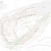
A large area of quarrying on the NNW flank of Traprain Law extends W from the modern car park for a distance of about 120m, with the majority of features situated on a terrace about 25m SE of the boundary wall that runs along the side of the public road. The largest individual feature is a quarry pit at NT 5804 7489, which has a floor that measures 20m from ENE to WSW by 12m transversely and is entered by way of a dog-leg track from the NNW. Earlier quarry features to the E are now obscured by the remains of the modern quarry (NT57SE 171), while 60m to the W there is another less distinct area of quarrying (NT57SE 184). The date of these quarries is not known, but the fact that none are depicted on the 1st edition of the OS 6-inch map (Haddingtonshire 1855, sheet 10) suggests that they are earlier in date.
Visited by HES (GFG, AM) 20 June 2018.
(TPR53)

