
Traprain Law


Building (Post Medieval), Clearance Cairn (Post Medieval), Enclosure (Post Medieval), Field Boundary (Period Unknown)
Site Name Traprain Law
Classification Building (Post Medieval), Clearance Cairn (Post Medieval), Enclosure (Post Medieval), Field Boundary (Period Unknown)
Canmore ID 360890
Site Number NT57SE 190
NGR NT 57722 74516
Datum OSGB36 - NGR
Permalink http://canmore.org.uk/site/360890


- Council East Lothian
- Parish Haddington
- Former Region Lothian
- Former District East Lothian
- Former County East Lothian
Field Visit (May 2017)
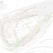
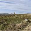
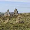
A roofless building stands at the foot of the west flank of Traprain Law and immediately E of a drystone dyke. Rectangular on plan with an entrance on the ENE, it measures about 8m from NNW to SSE by 6m transversely over lime-mortared stone walls that stand to gable height but have been reduced to their lower courses on both sides. There is a small clearance cairn 20m to the N of the building, while three linear features 15m to the NE are probably the result of grubbing out of an enclosure wall. A short section of field boundary 23m to the E, now marked by a grass-grown bank, may be of earlier date.
The building, or perhaps its predecessor, is depicted on Forrest’s Map of Haddingtonshire (c1803) situated a short distance N of farmstead called ‘Law end’, and it is possible the two were somehow associated with each other. The building is depicted roofed on the 1st edition of the OS 6-inch map (Haddingtonshire 1855, sheet 10), and is shown standing amidst enclosures of which there is now little trace. At this time ‘Lawend’ (NT57SE 118) is depicted largely roofed. However, less than 40 years later, the 2nd edition of the 25-inch map shows the building roofless and no enclosures. By this time, too, Lawend steading had been completely removed (Haddingtonshire 1894, sheet XI.1).
Visited by HES Survey and Recording (GFG, AM) May 2017.
(TPR 59)

