
Traprain Law


Lynchet (Period Unknown), Rig And Furrow (Period Unknown), Track (Modern)
Site Name Traprain Law
Classification Lynchet (Period Unknown), Rig And Furrow (Period Unknown), Track (Modern)
Canmore ID 360605
Site Number NT57SE 185
NGR NT 5853 7485
Datum OSGB36 - NGR
Permalink http://canmore.org.uk/site/360605


- Council East Lothian
- Parish Haddington
- Former Region Lothian
- Former District East Lothian
- Former County East Lothian
Field Visit (13 February 2018)
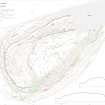
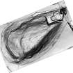
Visualisations of an image-based model (HES2017) show a plot of rig and furrow cultivation at the foot of the E flank of Traprain Law, extending over an area that measures about 110m from NE to SW by 40m transversely. The individual rigs are aligned NW and SE, and measure about 4m across. They are overlain by both a modern trackway which emerges from a gateway to the NE and a clearance cairn which measures about 6m by 3m on plan (at NT 58559 74861). A marked terrace at the foot of the rig extends for about 50m from NE to SW and stands about 1.5m in height; it is presumably a lynchet with both positive and negative elements.
Visited by HES Survey and Recording (GFG, ARG) 13 February 2018.
(TPR 46)

