
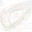
Traprain Law


Building (Medieval), Cup And Ring Marked Rock (Prehistoric), Coin (Copper)(17th Century), Jug (Pottery)(Medieval), Nail(S) (Iron)(Medieval), Saddle Quern (Stone)(Prehistoric), Samian (Pottery)(Roman), Scraper (Tool) (Period Unassigned)(Possible), Shot (Lead)(Post Medieval), Spearhead (Metal)(Period Unknown)(Possible), Unidentified Pottery (Pottery)(Prehistoric), Unidentified Pottery (Pottery)(Medieval)
Site Name Traprain Law
Classification Building (Medieval), Cup And Ring Marked Rock (Prehistoric), Coin (Copper)(17th Century), Jug (Pottery)(Medieval), Nail(S) (Iron)(Medieval), Saddle Quern (Stone)(Prehistoric), Samian (Pottery)(Roman), Scraper (Tool) (Period Unassigned)(Possible), Shot (Lead)(Post Medieval), Spearhead (Metal)(Period Unknown)(Possible), Unidentified Pottery (Pottery)(Prehistoric), Unidentified Pottery (Pottery)(Medieval)
Canmore ID 360554
Site Number NT57SE 183
NGR NT 58194 74630
Datum OSGB36 - NGR
Permalink http://canmore.org.uk/site/360554


- Council East Lothian
- Parish Haddington
- Former Region Lothian
- Former District East Lothian
- Former County East Lothian
Excavation (July 1996 - August 1996)
NT 582 746 A fire on the summit of Traprain Law, S of the visible prehistoric water tank, destroyed the vegetation in two adjoining areas, totalling some 300sqm. An NMS-led team removed and sieved the burnt deposits to reveal any underlying archaeology, and excavated three test trenches to assess the nature of and damage to surviving deposits. In both areas, Iron Age artefacts were recovered: around 40 sherds of pottery (including rim and base sherds), a small stone ball gaming piece, and a fragment of a shale ring. A number of pieces of burnt daub suggest buildings were present on this part of the hill.
In the W area, no archaeological deposits had been exposed by the fire, and two test trenches went straight onto bedrock. However, surviving stratigraphy may be expected in pockets. In the E area, in the lee of a rock outcrop, the fire had exposed the stone footings of a wall, which ran along a bedrock ridge before turning to utilise a right angle in the outcrop as two walls of the building: the smooth faces of the rock here suggest deliberate shaping. Traces of a collapsed turf wall lay to the S of the stone foundations. Inside the building, trial trenching revealed a much greater depth of soil (best seen as a collapsed organic roof) which overlay a roughly laid stone floor surface with large sherds of medieval green-glazed pottery upon it. The full details of this structure could not be traced in the scope of this exercise, but it measures 3.8m in internal width by at least 5m in length. It may be a shepherd's bothy, or have a connection with the watch beacon recorded on the Law in 1547. Deposits under this medieval activity were exposed in a rabbit scrape but not examined.
Sponsors: Historic Scotland, NMS, Edinburgh Archaeological Field Society.
F Hunter 1996
Excavation (July 1997)
NT 582 746 Investigations at Traprain Law in July 1997 recorded and partially excavated c 300m² of fire-damaged ground to the immediate S of the summit. The majority of the area excavated proved either to be outcropping bedrock or shallow sandy loam soils overlying bedrock. This soil contained a range of artefacts which appear to be mainly late prehistoric in origin. The remaining area contained a stretch of stone wall, perhaps an element of a late medieval structure associated with quantities of late medieval pottery.
Traprain Law is owned and managed by East Lothian Council who granted permission for these works to be undertaken.
Sponsor: Historic Scotland
T Rees 1997
Excavation (2004)
NT 582 746 Following a devastating fire on Traprain Law in late summer 2003 and subsequent assessment work (DES 2003, 62) a series of remedial excavations was carried out on various parts of the hill. During spring and summer 2004 work focused on a damaged part of the S fringe of the summit area, with additional trenches excavated in burnt areas on the upper slopes on the S, E and W sides of the hill. The aim was to recover archaeological evidence from areas damaged and left vulnerable by the recent fire, and to provide additional information to aid the future management of the site.
The main focus of the 2004 excavations on the S edge of the summit was the W half of the medieval building S of the pond, the E half having been dug in 1997 (PSAS 130, 413-40). From the earlier work it was known that the building was constructed partly of massive stone wall footings (along its S wall), and partly utilised bedrock (for its N and E walls), but partial excavation had not clarified the character of the occupation. Much additional information was recovered from the 2004 excavations. The massive foundation stones along the S side of the building had supported a turf superstructure, with individual turfs recognisable among the collapsed material. Two successive floor surfaces, incorporating paving and other internal features, were identified in the W half of the building, confirming that it had undergone a complex sequence of occupation. Interpretation in the building, and indeed across the site as a whole, was severely hindered by rabbit burrowing which has caused (and continues to cause) tremendous damage to the archaeological deposits on the Law.
Although there were numerous finds from the medieval building, most were clearly residual and added little to the 14th-century abandonment date suggested by pottery from the previous excavations. One intriguing find is a small stone fragment recovered from the turf wall core, which bears a series of distinctive linear carvings apparently from a rock art panel similar in style to those on the NE side of the hill which were destroyed during quarrying operations in the 1930s. The context of the fragment could be interpreted either as residual (in redeposited turf) or placed (as a wall foundation deposit).
Immediately N of the medieval building and just S of the pond, which forms one of the major visible features of the summit, an area of metalled flooring was identified. From the dense concentrations of cannel coal waste (mainly restricted to primary processing debris) above this surface, it has been interpreted as the remains of a specialised cannel coal working area of later prehistoric date. A further surface and wall underlay this but were not fully excavated.
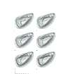
On the edge of the summit, just S of the medieval building, trenches were excavated over a terrace newly revealed by the fire. A series of stone wall footings and metalled surfaces associated with a hearth were identified; the walls did not survive well, but the structure(s) appeared to be sub-rectangular. Finds (including later prehistoric pottery, a stone ball and a whetstone) suggest a broadly Iron Age date. A flat area of outcropping bedrock, which had been used as part of a floor in the Iron Age, bore a series of earlier rock carvings. The motifs were dominated by pecked cupand- ring marks, with multiple rings and connecting radial grooves. However, there were also lozenge, chevron and other motifs of unusual character. In form and condition, the cup-and-ring marks parallel those found on the NE of the hill (see above) but without the linear motifs which predominate in the latter area.
Publication Account (2005)
One of the most unexpected results of the 2004 fieldwork on Traprain Law was the discovery of in situ rock carvings on the floor of a putatively Iron Age building on the southern edge of the summit. This was not the first rock art to be found at Traprain. During the 1930s, several large panels had been discovered during quarrying on the NE side of the hill [NT57SE 88]. Although Arthur Edwards from the National Museums of Scotland was able to records the carvings and take casts, the rock art itself was mercilessly blown up to allow quarrying to proceed. The casts and original fragments, preserved in the NMS stores, had been the subject of re-evaluation by the present authors prior to the present discoveries. They are a an extraordinary collection; a suite of complex cup-and-ring markings in the conventional Atlantic European style, overlain by a unique set of linear motifs seemingly related to the to the decorative styles present in the Cordoned Urn pottery tradition.
The new panel [NT57SE 183] corresponds to the earlier phase of carving, and consists of at least five cup-and-ring marks, three of which are conjoined. There are also faint traces of small rosettes, possible chevrons and at least one lozenge, suggesting similarities to passage grave art.
It is rare for in situ rock art to be discovered stratigraphically sealed in an archaeological excavation. Although partly covered by the metalled floor of the later building, the most complex cup-and-ring motifs in the panel would have been 'on display' within the floor of the later building, close by the hearth. Although it is tempting to see this as a deliberate act of incorporation of the earlier art within the new building, the exposed motifs were very faint and the re-use of this outcrop may have been fortuitous.
[Illustrations include interpretative plan of revealed rock art].
I Armit and M McCartney 2005
Field Visit (7 November 2017)
The remains of a rectangular building that may be of medieval date are set against the SE side of a bedrock outcrop 40m SE of the triangulation pillar on the summit of Traprain Law. It measures at least 9m from NE to SW by 3.4m transversely within a wall with faces marked by edge-set slabs. The building was first identified as a possible hut site in 1955 (HES Archive: DP249999), but it was not depicted on the final RCAHMS plan (Feachem 1958). During 1996 and 1997 it, together with an irregular area to the W, was excavated by AOC Archaeology Group and the National Museums of Scotland (NMS) following a fire on the hillside. Finds from the excavation ranged in date from early prehistoric to post-medieval, but a concentration of finds of 13th and 14th century AD date from within the building provide an indication of its date (Rees and Hunter 2000).
In 2004, following another fire, further excavation was undertaken in this area by a team from Queen’s University Belfast, NMS and CFA Archaeology Ltd (HES Archive: MS2673, Trenches B-D and H). The most significant find was undoubtedly the exposure of prehistoric cup-and-ring markings on the bedrock at NT c. 58204 64618, which was subsequently turfed over.
Visited by HES Survey and Recording (GFG) 7 November 2017.
(TPR27)

