
Traprain Law


Well (Period Unknown)
Site Name Traprain Law
Classification Well (Period Unknown)
Canmore ID 360145
Site Number NT57SE 182
NGR NT 58121 74782
Datum OSGB36 - NGR
Permalink http://canmore.org.uk/site/360145


- Council East Lothian
- Parish Prestonkirk
- Former Region Lothian
- Former District East Lothian
- Former County East Lothian
Field Visit (29 November 2017)
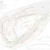
A stone-lined spring is situated on the N flank of Traprain Law within the fort, and 130m NNW of the summit. It is marked by a natural bedrock fissure about 1.2m in diameter and 0.5m in depth. An excavation undertaken in 2000 (MS726/198, Trench 9) provided evidence that the spring once had some form of cap and that a culvert had been created carrying water to the north. At present there is no secure dating for the stone embellishment to the spring.
The feature is depicted on the revised 2nd edition of the OS 25-inch map (Haddingtonshire 1907, sheet 11.1), and on the plans published by RCAHMS (1924, 95; Feachem 1958).
Visited by HES Survey and Recording (GFG, AM) 29 November 2017
(TPR 32)

