
Following the launch of trove.scot in February 2025 we are now planning the retiral of some of our webservices. Canmore will be switched off on 24th June 2025. Information about the closure can be found on the HES website: Retiral of HES web services | Historic Environment Scotland
Traprain Law


Building(S) (Period Unassigned), Farmstead (Medieval)(Possible), Rotary Quern (Middle Iron Age), Unidentified Pottery (Period Unassigned)
Site Name Traprain Law
Classification Building(S) (Period Unassigned), Farmstead (Medieval)(Possible), Rotary Quern (Middle Iron Age), Unidentified Pottery (Period Unassigned)
Canmore ID 360144
Site Number NT57SE 181
NGR NT 58137 74755
Datum OSGB36 - NGR
Permalink http://canmore.org.uk/site/360144


!['Plan of Traprain Law', showing contours, annotated with the position of Curle and Cree's trenches, and the find spot of a 'silver chain' [1938]](http://i.rcahms.gov.uk/canmore/l/DP00248534.jpg)


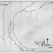


!['Plan of Traprain Law', showing contours, annotated with the position of Curle and Cree's trenches, and the find spot of a 'silver chain' [1938]](http://i.rcahms.gov.uk/canmore/s/DP00248534.jpg)


- Council East Lothian
- Parish Prestonkirk
- Former Region Lothian
- Former District East Lothian
- Former County East Lothian
Field Visit (29 November 2017)
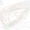
A group of three buildings and remnants of a field-system, probably representing the remains of a medieval or post-medieval farmstead, is situated on a terrace on the N flank of Traprain Law about 100m NNW of the summit. The best preserved building (TPR31) measures 12.2m from ENE to WSW by 4.1m transversely within a grass-grown stony bank about 1.9m in thickness, possibly broken by an entrance on the SSE. Just 5m to the E there are the remains of a second and similar building (TPR30), while a further 35m to the E are the remains of a third (TPR28). Two other buildings shown on earlier plans do not bear scrutiny. A number of walls, now reduced to little more than discontinuous runs of stones and small boulders, may be the remains of a contemporary yards around the buildings. A track that leads off the W, presumably through a later entrance to the fort, may also be contemporary.
The second building (TPR30) was partly excavated in 2000 (MS726/198, Trench 8) exposing a wall built of stone and turf. Finds that pre-dated the building included wheel-thrown pottery and the upper stone of a bun-shaped rotary quern (possibly Roman-British in date). These finds, combined with the plan of the buildings, and their good condition (compared to other structures on the hill), suggest that the farmstead may be of medieval or later date.
The buildings were depicted on the revised 2nd edition of the OS 25-inch map (Haddingtonshire 1907, sheet 11.1) and on the plans published by RCAHMS (1924, 95; Feachem 1958), though no description was provided since they were thought to be relatively late in date.
A series of boulder walls immediately surrounding the farmstead are probably simply the remains of associated enclosures, although they may have extended to form a small field system.
Visited by HES Survey and Recording (GFG, AM) 29 November 2017
(TPR 28, 30, 31)

