
Traprain Law


Quarry(S) (Post Medieval)
Site Name Traprain Law
Classification Quarry(S) (Post Medieval)
Canmore ID 360127
Site Number NT57SE 179
NGR NT 58274 74897
Datum OSGB36 - NGR
Permalink http://canmore.org.uk/site/360127


- Council East Lothian
- Parish Prestonkirk
- Former Region Lothian
- Former District East Lothian
- Former County East Lothian
Field Visit (22 February 2018)
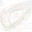
A large quarry is situated on the N flank of Traprain Law about 120m S of the car park, 125m E of the magazines and above the terrace rampart of the fort (NT57SE 1). The quarry floor measures about 27m from NE to SW by 15m transversely, and the rear face measures about 7m in height. At least three smaller quarries have been recorded between here and the powder magazines (NT57SE 171.1), each of which was depicted on the RCAHMS plan prepared in 1955 (Feachem 1958). An opening through the fort rampart just to the N may have provided access to these and other quarries by way of a track.
Visited by HES Survey and Recording (GFG, AM) 22 February 2018.
(TPR 15-18)

