Traprain Law
Enclosure (18th Century), Plantation (18th Century)(Possible), Sheepfold (Post Medieval)(Possible)
Site Name Traprain Law
Classification Enclosure (18th Century), Plantation (18th Century)(Possible), Sheepfold (Post Medieval)(Possible)
Canmore ID 360067
Site Number NT57SE 177
NGR NT 58151 74657
Datum OSGB36 - NGR
Permalink http://canmore.org.uk/site/360067
- Council East Lothian
- Parish Prestonkirk
- Former Region Lothian
- Former District East Lothian
- Former County East Lothian
Field Visit (26 April 2017)
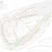
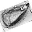
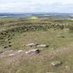
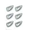
A ruinous and robbed enclosure stands immediately WSW of the summit of Traprain Law (221m OD). Oval on plan, it measures 16m from E to W by 15m transversely within a stone wall 1m in thickness and up to 0.3m in height in a single course. The enclosure is depicted on the 1st edition of the OS 6-inch map and annotated ‘sheepfold’ (Haddingtonshire 1855, Sheet 10) and it features on most subsequent plans of the Law (e.g. Curle 1914; Feachem 1958), though it escaped notice in previous written accounts perhaps because of its late date (Feachem 1958; Jobey 1976). There is no evidence to support the suggestion by Hill (1987, 90; cf. Close-Brooks 1987, 93) that it was one of a group of Roman temple buildings. Because of a perceived question over the date of the enclosure, it was excavated in 1999 (MS 726/177, pp.19-26, 81) at which time it was interpreted as a modern enclosure. Finds recovered, which indicate the background of activity on the summit, included prehistoric and medieval pottery sherds.
The most likely explanation for the enclosure is provided by an account from 1792: ‘several years ago, a small plantation, of different kinds of trees, was made on the summit, by way of experiment, and inclosed [sic] with a stone dyke, or wall, six feet high. The trees succeeded very well, while they were sheltered by the wall; but, since that time, they have not made the smallest progress’ (Stat. Acct. II, 350; see also Curle 1914, 140). Two other enclosures, probably of the same date and function, stand within the summit area (NT57SE 174; NT57SE 188).
Visited by HES Survey and Recording (GFG) 26 April 2017
(TPR51)


