
Traprain Law


Shelter (20th Century), Triangulation Pillar (20th Century), Triangulation Station (19th Century)
Site Name Traprain Law
Classification Shelter (20th Century), Triangulation Pillar (20th Century), Triangulation Station (19th Century)
Canmore ID 360066
Site Number NT57SE 176
NGR NT 58165 74662
Datum OSGB36 - NGR
Permalink http://canmore.org.uk/site/360066


- Council East Lothian
- Parish Prestonkirk
- Former Region Lothian
- Former District East Lothian
- Former County East Lothian
Field Visit (26 April 2017)
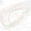
This Ordnance Survey triangulation pillar, computed in 1943, is situated within the hillfort (NT57SE 1) on the summit of Traprain Law (221m OD). Square on plan with narrow chamfered corners, it measures about 0.6m square at the base and tapers to a flat top at 1.2m, where there is a brass mounting plate and retaining hoops for a theodolite. A brass flush bracket on the side of the pillar bears the number S3065.
The Ordnance Survey’s 19th century triangulation station is depicted on the 1st edition of the OS 6-inch map (Haddingtonshire Sheet 10, 1855) standing some 6m to the N and both the old and new stations are shown on a 1955 plan by RCAHMS (DP249999). The site of the earlier station is now occupied by a drystone walkers’ shelter which measures about 2.5m in diameter within a roughly built wall about 1m in thickness and 1m in height.
Visited by HES Survey and Recording (GFG) 26 April 2017.
(TPR1)

