
Following the launch of trove.scot in February 2025 we are now planning the retiral of some of our webservices. Canmore will be switched off on 24th June 2025. Information about the closure can be found on the HES website: Retiral of HES web services | Historic Environment Scotland
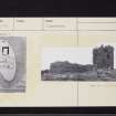
Red Castle, Lunan


Castle (Medieval), Midden (Medieval)
Site Name Red Castle, Lunan
Classification Castle (Medieval), Midden (Medieval)
Alternative Name(s) Redcastle; Red Castle, Enceinte And Keep
Canmore ID 35792
Site Number NO65SE 10
NGR NO 68783 51079
Datum OSGB36 - NGR
Permalink http://canmore.org.uk/site/35792


- Council Angus
- Parish Inverkeilor
- Former Region Tayside
- Former District Angus
- Former County Angus
NO65SE 10.00 68783 51079
NO65SE 10.01 NO 687 510 Lead ball
(NO 6878 5108) Red Castle (NR)
OS 6" map (1971)
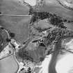
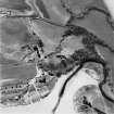
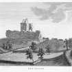
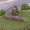
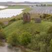
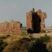
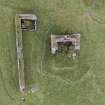
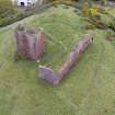
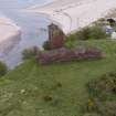
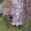
Redcastle, situated on a promontory and isolated by a ditch, was founded as a hunting seat by William the Lion (1165-1214) was besieged in 1579 and was ruinous although still partly roofed in 1770. The remains now consist of a possibly 13th century fragment of the massive wall of enceinte and the ruin of the 15th century rectangular tower. The name comes from the red freestone ashlar of which it is constructed.
(D MacGibbon and T Ross 1887; G Hay 1899; W D Simpson 1941; A J Warden 1884)
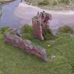
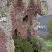
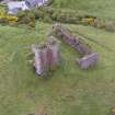
The remains of Red Castle are in a crumbling condition and very weathered. The enceinte wall is 6m high and 2m thick. A fragment can be traced just below ground level on the edge of the escarpment at the NE angle of the keep. Of the keep, the N wall and the returns of the E and W walls stand at or near their original height and are 1.7m thick. The S part of the keep is fragmentary, 1.2m high and grass-covered. The remains of a building in the N angle of the enceinte wall are modern. A slight indentation, 2.0m deep, in the natural slope c.10.0m NW of the curtain wall may represent the E end of the ditch but otherwise there is no trace of it.
Visited by OS (JLD) 19 June 1958
EXTERNAL REFERENCE:
Scottish Record Office.
Brief descriptions of small houses in the barony of Redcastle.
1725-1726 GD 45/18/1275
Public Library (Edinbirgh Room) Scots Magazine, December 1810 - 1 engraving
NMRS REFERENCE
Ruin.
Field Visit (March 1978)
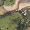
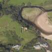
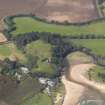
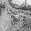
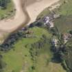
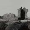
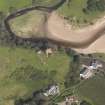
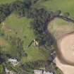
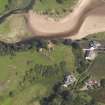
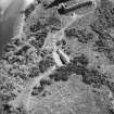
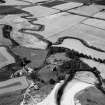
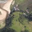
The ruins of this fine castle occupy a steep-sided promontory on the S side of the Lunan Water, where the river empties into the sea. The visible remains, which consist of part of a 13th-century curtain wall and a 15th-century tower, may occupy the site of an earlier castle. Finds from a midden deposit at the foot of the slope on the NE side of the promontory have been donated to the National Museum of Antiquities of Scotland.
RCAHMS, visited March 1978
(Simpson 1941; Wilson 1961, 325)
Field Visit (March 1978)
Red Castle NO 687 510 NO65SE 10
The ruins of this fine castle occupy a steep-sided promontory on the S side of the Lunan Water, where the river empties into the sea. The visible remains, which consist of part of a 13th-century curtain wall and a 15th-century tower, may occupy the site of an earlier castle. Finds from a midden deposit at the foot of the slope on the NE side of the promon¬tory have been donated to the National Museum of Antiquities of Scotland.
RCAHMS 1978, visited March 1978
(Simpson 1941; Wilson 1961, 325)
Note (1983)
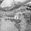
Re-examination of the continually eroding kitchen midden below Red Castle, resulted in the recording in situ of numerous shell species as well as post-medieval pottery, bone, baked clay and roofing tiles; in Montrose Museum.
J R Sherriff 1983.
Excavation (1983)
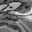
A narrow (but deep) excavation across the linear ditch uncovered an original medieval (12th/13th century) ditch with dump rampart cutting and sealing ploughsoil which in turn truncated a collection of scoops and postholes related to early medieval/dark ages occupation.
A Gibson and D Pollock 1983.
Earth Resistance Survey (1983)
Contour, auger and resistivity surveying of the knoll around the castle produced indications of two ditches, one running straight to cut the knoll in two, the other running concentric to, and just outside the 13th century upstanding curtain wall, with a narrow causeway.
A Gibson and D Pollock 1983.
Aerial Photography (1997)
Air photographs: AAS/97/11/G22/24, 25 and 28; AAS/97/11/CT.
NMRS, MS/712/29.
Note (10 February 1999)
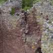
This tower is in imminent danger of collapse, since the NE corner, which is the most complete part, has become undermined by land slippage. The foundation layer of grey-coloured broken rubble is exposed on this side. The lower of the two remaining windows on the E side has also collapsed, leaving the upper as a dangerous overhang.
Information from I Edwards to RCAHMS, 10 February 1999.

