Accessibility

Font Size

100% 150% 200%

Background Colour

Default Contrast
Close Reset

Dun

Ring Ditch(S) (Prehistoric)(Possible)

Site Name Dun

Classification Ring Ditch(S) (Prehistoric)(Possible)

Canmore ID 35680

Site Number NO65NE 28

NGR NO 6880 5930

NGR Description Centred on NO 6880 5930

Datum OSGB36 - NGR

Permalink http://canmore.org.uk/site/35680

Ordnance Survey licence number AC0000807262. All rights reserved.
Canmore Disclaimer. © Bluesky International Limited 2025. Public Sector Viewing Terms

Toggle Aerial | View on large map

Digital Images

Oblique aerial view centred on the cropmarks of the Roman Temporary Camp, ring ditches, enclosure, lienar features, pits and rig at Dun and Gilrivie, looking to the NNE.
Oblique aerial view centred on the cropmarks of the Roman Temporary Camp, ring ditches, enclosure, lienar features, pits and rig at Dun and Gilrivie, looking to the NNE.Oblique aerial view centred on the cropmarks of the Roman Temporary Camp, ring ditches, round houses and rig and furrow at Dun, taken from the W.Oblique aerial view.Oblique aerial view.Oblique aerial view centred on the cropmarks of the Roman Temporary Camp, ring ditches, round houses and rig and furrow at Dun, taken from the SSW.Oblique aerial view centred on the cropmarks at Gilrivie, looking NNE.Oblique aerial viewOblique aerial view.Dun, oblique aerial view, taken from the NW, centred on the cropmarks of a Roman Temporary Camp and a ring-ditch.Oblique aerial view.Oblique aerial view centred on the cropmarks of the Roman Temporary Camp, ring ditches, round houses and rig and furrow at Dun, taken from the SW.Dun, NO65NE 28, Ordnance Survey index card, RectoDun, oblique aerial view, taken from the SW, centred on the cropmarks of a Roman Temporary Camp and a ring-ditch.Dun, NO65NE 28, Ordnance Survey index card, page number 1, RectoOblique aerial view centred on the cropmarks of the Roman Temporary Camp, ring ditches, round houses and rig and furrow at Dun, taken from the NE.Oblique aerial viewOblique aerial view.Oblique aerial view centred on the cropmarks of the Roman Temporary Camp, ring ditches, round houses and rig and furrow at Dun, taken from the NNW.Oblique aerial view centred on the cropmarks of the Roman Temporary Camp, ring ditches, round houses and rig and furrow at Dun, taken from the NW.Oblique aerial view of cropmarks of the Roman camp, linear features, enclosures, ring ditches and rig, looking NNW.Oblique aerial view of cropmarks of the Roman camp, linear features, enclosures, ring ditches and rig, looking W.Oblique aerial view centred on the cropmarks of the Roman Temporary Camp and ring-ditches, taken from the SE.Oblique aerial view of cropmarks of the Roman camp, linear features, enclosures, settlement and rig, looking NNW.Oblique aerial view of cropmarks of the Roman camp, enclosures, ring ditches and rig, looking N.Oblique aerial view of cropmarks of the Roman camp, linear features, enclosures, ring ditches and rig, looking SW.Oblique aerial view.Oblique aerial view.Oblique aerial view.Dun, oblique aerial view, taken from the ENE, centred on the cropmarks of a Roman Temporary Camp and a ring-ditch.Oblique aerial view centred on the cropmarks of the Roman Temporary Camp and ring-ditches, taken from the NW.Oblique aerial view centred on the cropmarks of the Roman Temporary Camp and ring-ditches, taken from the SE.Oblique aerial view.Oblique aerial view of cropmarks of the Roman camp, linear features, enclosures, ring ditches and rig, looking NW.Oblique aerial view of cropmarks of the Roman camp, linear features, enclosures, ring ditches and rig, looking SSW.Oblique aerial view centred on the cropmarks of the Roman Temporary Camp and ring-ditches, taken from the NNW.Oblique aerial view centred on the cropmarks of the Roman Temporary Camp and ring-ditches, taken from the WSW.

Administrative Areas

  • Council Angus
  • Parish Dun
  • Former Region Tayside
  • Former District Angus
  • Former County Angus

Activities

Field Visit (April 1978)

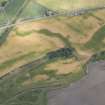
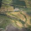
Dun NO 688 593 NO65NE

A number of crop-marks have been recorded at the top of the slope that runs up from the Montrose basin to the level ground on which the Roman temporary camp (NO65NE 21) is situated. Two ring-ditches, measuring about 15m in diameter, lie within the SW and NW quadrants of the camp respectively and at least one other of comparable size lies outside the camp to the S, together with at least three small circular markings, one of which is penannular, and another may be a ditched barrow measuring about 10m in diameter.

RCAHMS 1978, visited April 1978

References

MyCanmore Image Contributions


Contribute an Image

MyCanmore Text Contributions