Accessibility

Font Size

100% 150% 200%

Background Colour

Default Contrast
Close Reset

Dun

Temporary Camp (Roman), Samian (Pottery)(Roman)

Site Name Dun

Classification Temporary Camp (Roman), Samian (Pottery)(Roman)

Canmore ID 35673

Site Number NO65NE 21

NGR NO 6890 5959

NGR Description Centred on NO 6890 5959

Datum OSGB36 - NGR

Permalink http://canmore.org.uk/site/35673

Ordnance Survey licence number AC0000807262. All rights reserved.
Canmore Disclaimer. © Bluesky International Limited 2025. Public Sector Viewing Terms

Toggle Aerial | View on large map

Digital Images

Oblique aerial view centred on the cropmarks of the Roman Temporary Camp, ring ditches, enclosure, lienar features, pits and rig at Dun and Gilrivie, looking to the NNE.
Oblique aerial view centred on the cropmarks of the Roman Temporary Camp, ring ditches, enclosure, lienar features, pits and rig at Dun and Gilrivie, looking to the NNE.Oblique aerial view centred on the cropmarks of the Roman Temporary Camp, ring ditches, round houses and rig and furrow at Dun, taken from the W.Oblique aerial view.Oblique aerial view.Oblique aerial view.Oblique aerial view.Oblique aerial view centred on the cropmarks of the Roman temporary camp, linear features, pits and rig at Dun, looking to the NW.Oblique aerial view centred on the cropmarks of the Roman Temporary Camp, ring ditches, round houses and rig and furrow at Dun, taken from the SSW.Oblique aerial view centred on the cropmarks at Gilrivie, looking S.Oblique aerial view centred on the cropmarks at Gilrivie, looking NNE.Oblique aerial viewOblique aerial view.Oblique aerial view.Dun, oblique aerial view, taken from the NW, centred on the cropmarks of a Roman Temporary Camp and a ring-ditch.Oblique aerial view.Oblique aerial view centred on the cropmarks of the pits and possible enclosure at Gilrivie, taken from the SW.Oblique aerial view centred on the cropmarks of the Roman Temporary Camp, ring ditches, round houses and rig and furrow at Dun, taken from the SW.Oblique aerial view centred on the cropmarks of the linear features, Roman temporary camp, pits and rig with the farm adjacent at Gilrivie and Dun, looking to the ESE.Oblique aerial view.Dun, oblique aerial view, taken from the SW, centred on the cropmarks of a Roman Temporary Camp and a ring-ditch.Dun, NO65NE 21, Ordnance Survey index card, page number 1, RectoOblique aerial view centred on the cropmarks of the Roman Temporary Camp, linear features, enclosure, pits and rig at Gilrivie with the farmstead adjacent, looking to the WNW.Oblique aerial view centred on the cropmarks of the Roman Temporary Camp, ring ditches, round houses and rig and furrow at Dun, taken from the NE.Oblique aerial viewOblique aerial view.1 Aug 1979Dun, NO65NE 21, Ordnance Survey index card, RectoOblique aerial view.Oblique aerial view centred on the cropmarks of the roundhouses and ring ditches of the unenclosed settlement with the farmstead adjacent at Newbigging, looking to the NW.Oblique aerial view centred on the cropmarks of the Roman Temporary Camp, ring ditches, round houses and rig and furrow at Dun, taken from the NNW.Oblique aerial view centred on the cropmarks of the Roman Temporary Camp, ring ditches, round houses and rig and furrow at Dun, taken from the NW.Oblique aerial view of cropmarks of the Roman camp, linear features, enclosures, ring ditches and rig, looking NNW.Oblique aerial view of cropmarks of the Roman camp, enclosures, ring ditches and rig, looking N.Oblique aerial view of cropmarks of the Roman camp, linear features, enclosures, ring ditches and rig, looking W.Oblique aerial view centred on the cropmarks of the Roman Temporary Camp and ring-ditches, taken from the SE.Dun, NO65NE 21, Ordnance Survey index card, RectoOblique aerial view centred on the cropmarks of the Roman Temporary Camp, ring ditches, enclosure, lienar features, pits and rig at Dun and Gilrivie, looking to the NNW.Oblique aerial view centred on the cropmarks of the enclosure,  linear features, Roman temporary camp, pits and rig with the farm adjacent at Gilrivie and Dun, looking to the ESE.Oblique aerial view of cropmarks of the Roman camp, linear features, enclosures, settlement and rig, looking NNW.Oblique aerial view of cropmarks of the Roman camp, enclosures, ring ditches and rig, looking N.Oblique aerial view of cropmarks of the Roman camp, linear features, enclosures, ring ditches and rig, looking SW.Oblique aerial view.Oblique aerial view.Oblique aerial view.Oblique aerial view.Oblique aerial view.Oblique aerial view.Oblique aerial view.Oblique aerial view.Oblique aerial view.Oblique aerial view.Dun, oblique aerial view, taken from the ENE, centred on the cropmarks of a Roman Temporary Camp and a ring-ditch.Oblique aerial view centred on the cropmarks of the Roman Temporary Camp and ring-ditches, taken from the NW.Oblique aerial view centred on the cropmarks of the Roman Temporary Camp and ring-ditches, taken from the SE.1 Aug 1979Oblique aerial view.Dun, NO65NE 21, Ordnance Survey index card, RectoOblique aerial view centred on the cropmarks of an unenclosed settlement, linear features, souterrains and pits at Gilrivie, looking to the N.Oblique aerial view centred on the cropmarks of an unenclosed settlement, linear features, souterrains and pits at Gilrivie, looking to the NNW.Oblique aerial view centred on the cropmarks of the roundhouses and ring ditches of the unenclosed settlement with the farmstead adjacent at Newbigging, looking to the WNW.Oblique aerial view centred on the cropmarks of the Roman Temporary Camp, linear features, enclosure, pits and rig at Gilrivie with the farmstead adjacent, looking to the NW.Oblique aerial view of cropmarks of the Roman camp, linear features, enclosures, ring ditches and rig, looking NW.Oblique aerial view of cropmarks of the Roman camp, linear features, enclosures, ring ditches and rig, looking SSW.Oblique aerial view.Oblique aerial view.Oblique aerial view.Oblique aerial view.Oblique aerial view.Oblique aerial view.Oblique aerial view centred on the cropmarks of the Roman Temporary Camp and ring-ditches, taken from the NNW.Oblique aerial view centred on the cropmarks of the Roman Temporary Camp and ring-ditches, taken from the WSW.

Administrative Areas

  • Council Angus
  • Parish Dun
  • Former Region Tayside
  • Former District Angus
  • Former County Angus

Archaeology Notes

NO65NE 21 centred 6890 5959.

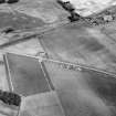
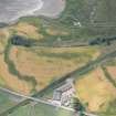
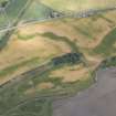
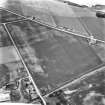
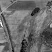
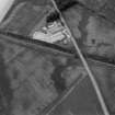
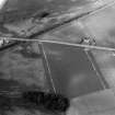
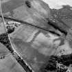
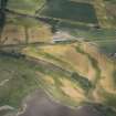
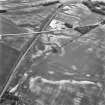
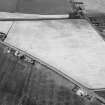
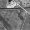
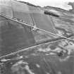
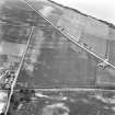
(NO 6890 5959) Roman Camp (Site), Dun: Air photographs show a small enclosure measuring 545 ft E-W by 660 ft (8 acres in area), with rounded corners and two gates, one each in the E and W sides. Identification as a Roman camp was confirmed by the V-shaped ditch exposed in two trial sections, one of which yielded a piece of late 1st century Samian ware near the bottom of the silt filling.

J K St Joseph 1973.

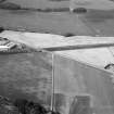
This camp was threatened in 1990 by a replacement of the gas main along the A935 which cuts through the centre of the camp. Two areas were excavated along the line of the new pipe, where it would pass through the camp ditch. The east camp ditch proved to have already been disturbed by existing gas and water mains in this area. A section of the west ditch was excavated. It had an "ankle breaker" profile, V-shaped with a square slot along the bottom, and had rapidly silted after cutting before being deliberately backfilled.

Sponsors: HBM; British Gas.

I M Rogers 1990c.

Activities

Field Visit (April 1978)

Dun NO 688 595 NO65NE 21

A small Roman temporary camp covering an area of about 3.2ha has been identified as a cropmark on level ground above the N fringe of the Montrose Basin. A piece of late 1st century samian ware was found near the bottom of the ditch-fill.

RCAHMS 1978, visited April 1978

(St Joseph 1973, 225)

Publication Account (17 December 2011)

This camp, situated on level ground on the north side of the Montrose Basin, was first discovered by St Joseph from the air through cropmarks in 1970 (1973: 225). It measures about 185m from NN W to SSE by around 160m transversely, enclosing 2.8ha (7 acres). An entrance gap protected by a titulus is visible towards the south end of the ENE side, and there is a corresponding break in the opposite side.

St Joseph placed trenches on the SSE and WSW sides in 1970, recording that the ditch was 2.3m wide and 1.2m deep. A small piece of samian recovered from these excavations was dated to ad 70–90 (1973: 225). Further excavations were made by Rogers in 1990, in advance of the replacement of a gas main alongside the road. These recorded that the ditch was V-shaped, and measured up to 1.5m wide and about 1m deep. The excavators noted that the ditch had silted rapidly (Rogers 1993: 287–8).

R H Jones

References

MyCanmore Image Contributions


Contribute an Image

MyCanmore Text Contributions