
River Clyde, Old Kilpatrick Light


Beacon (20th Century)
Site Name River Clyde, Old Kilpatrick Light
Classification Beacon (20th Century)
Canmore ID 356433
Site Number NS47SE 378
NGR NS 46338 72417
Datum OSGB36 - NGR
Permalink http://canmore.org.uk/site/356433


- Council West Dunbartonshire
- Parish Old Kilpatrick (Dumbarton)
- Former Region Strathclyde
- Former District Dumbarton
- Former County Dunbartonshire
Field Visit (26 October 2017)
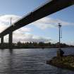
This navigation light, which is first depicted on the 1:1250 OS Grid map (1958, Sheet NS 4672SW-A) and annotated ‘Old Kilpatrick Light (Group Flashing Red)’, stands on the NE bank of the River Clyde 130m downstream from the Erskine Ferry (NS47SE 205). It comprises a rectangular concrete plinth into which a red-painted iron pole with a light on top has been set. The light is accessed by a ladder that extends half way down the pole from beneath a small square platform with railings.
Visited by HES Survey and Recording (AMcC, ATW) 26 October 2017.

