Eilean Fhianain, North East Platforms
Building(S) (Post Medieval), Grave Marker(S) (Post Medieval), Gravestone (19th Century), Hut (Post Medieval)(Possible), Platform(S) (Post Medieval), Settlement (Post Medieval)
Site Name Eilean Fhianain, North East Platforms
Classification Building(S) (Post Medieval), Grave Marker(S) (Post Medieval), Gravestone (19th Century), Hut (Post Medieval)(Possible), Platform(S) (Post Medieval), Settlement (Post Medieval)
Alternative Name(s) Platforms 9-10, 13-24
Canmore ID 356244
Site Number NM76NE 1.14
NGR NM 75264 68343
Datum OSGB36 - NGR
Permalink http://canmore.org.uk/site/356244
- Council Highland
- Parish Arisaig And Moidart
- Former Region Highland
- Former District Lochaber
- Former County Inverness-shire
Field Visit (5 September 2017)
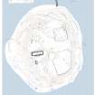
The numbers cited in this description refer to a plan of the island.
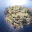
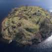
This group of up to 11 grass- and reed-grown platforms occupies the NE shore of the island between the old and new jetties. At least four of the platforms (Nos. 10, 16, 17 and 20) appear to have been constructed to support buildings of which only vestiges remain, perhaps of secondary date. Platforms 18 and 19 were presumably constructed for burials, and contain two small cairns, a few grave markers and a single gravestone.
This area has clearly been the focus of later settlement on the island, and occupies the most sheltered part. A document from 1707 records that the minister had stayed with a blacksmith resident on the island (NAS CHP/984/2) and local tradition records that the last family left the island in the 18th century (Macdonald 2011 edn., 102-3) suggesting that, on the present evidence, the settlement here is of post-medieval date.
9. NM 75251 68341: This oval platform, which is cut back into the steep slope on the NNE side of the island, measures 6.5m from NW to SE by 4.8m transversely, with a rear scarp 0.4m high and a front apron up to 0.25m high.
10. NM 75258 68345: This subrectangular platform, which is cut back into the steep slope on the NE side of the island, measures 11.7m from NW to SE by 7.3m transversely, with a rear scarp 0.3m high and a front apron up to 0.3m high. Fragments of slag have been noted on the below the crest of the apron.
13. NM 75251 68358: This platform, which is cut back into the steep slope on the NNE side of the island, measures 5.5m square within a rear scarp 0.5m high and a front apron 0.3m high.
14. NM 75255 68357: This oval platform, which is cut back into the steep slope on the NNE side of the island, measures 6.8m from N to S by 4.2m transversely within a rear scarp 1.2m high and a front apron 0.6m high. Faint traces of a low bank cross the platform at right-angles.
15. NM 75261 68355: This oval platform, which is cut back into the steep slope on the NNE side of the island, measures 7.8 from NW to SE by 6.6m transversely within a rear scarp 0.4m high and a front apron 0.25m high.
16. NM 75269 68349: This subrectangular platform, which is cut back into the steeply rising slope on the NNE side of the island, measures 15.8m from NNW to SSE by 5.2m transversely within a rear scarp 2.3m high and a front apron 0.8m high. What may be the remains of a hut measuring 3.2m from NNW to SSE by 3m transversely within spread turf banks 1m thick and 0.15m high are situated at the SE end. A fragment of slag lies under an alder to the NE of the platform.
17. NH 75281 68326: This subrectangular platform, which is cut back into the steep slope on the NE side of the island, measures 24.3m from NNW to SSE by 7.6m transversely within a rear scarp 1.3m high and a front apron 1.2m high. The remains of two possible buildings measuring about 11m and 10.5m long respectively lie on the platform. The more northerly is most clearly represented by the curved spread bank at the NNW end of the platform, which measures 1.7m thick and 0.35m high, the more southerly by a disturbed area and what appear to be spread turf walls 1m thick and 0.1m high at the SSE end of the platform.
18. NM 75264 68330: This oval platform, which is cut back into the steep slope on the NE side of the island, measures 5.7m from NNW to SSE by 6.1m transversely, with a rear scarp 2.2m high. It is occupied by a Late Victorian headstone marking the grave of Andrew Gillies (d.1881) and Isabella Macdonald, immediately to the ESE of which is a small rubble cairn. In addition, a line of boulders extends 2m S from the foot of the headstone.
19. NM 75268 68325: This oval platform, which is cut back into the steep rising slope on the NE side of the island, measures 6.1m from NNW to SSE by 5.5m transversely within a rear scarp 2.5m high and a front apron 0.2m high. A scatter of stones at the centre originates from a small cairn.
20. NM 75276 68309: This subrectangular platform, which is cut back into the steep slope on the E side of the island, measures 13m from N to S by 6.6m transversely within a rear scarp 1.5m high and a front apron 0.3m high. The remains of a turf building, measuring 2m square within spread turf walls 0.8m thick and 0.1m high, are situated at its N end. What may be an entrance is marked by a faint gap on the E.
21. NM 75288 68306: This oval platform, which is cut back into the steep rising slope on the E side of the island, measures 11.3m from N to S by 6.2m transversely within a rear scarp 0.7m high and a front apron 0.5m high. Fragments of iron slag occur at the NNE corner.
Visited by HES, Archaeological Survey (ATW, GFG) 5 September 2017.


