
Pricing Change
New pricing for orders of material from this site will come into place shortly. Charges for supply of digital images, digitisation on demand, prints and licensing will be altered.
Milton


Quarry (Post Medieval)
Site Name Milton
Classification Quarry (Post Medieval)
Canmore ID 355353
Site Number NH54NE 94
NGR NH 57884 49496
Datum OSGB36 - NGR
Permalink http://canmore.org.uk/site/355353


- Council Highland
- Parish Killearnan
- Former Region Highland
- Former District Ross And Cromarty
- Former County Ross And Cromarty
Note (30 August 2017)
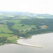
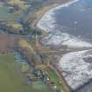
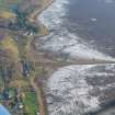
This disused and now overgrown sandstone quarry is situated 85m E of Killearnan parish church (NH54NE 44), where it has been dug into the face of an old sea-cliff. Of irregular plan, it measures about 250m from ENE to WSW by 90m transversely and there has been an entrance on the SSE, leading out towards the pier (NH54NE 71) from which much of the quarried stone was transported. The quarry was already abandoned when it was depicted on the 1st edition of the OS 25-inch map (Ross-shire 1880, Sheet C.5 and 1881, Sheet XCIX.8) and the contemporary Name Book (Vol. 15, p.36) notes that the pier ‘is supposed to have been partially constructed by Oliver Cromwell’ ....[and]....’used for shipping stone from quarries in the vicinity’. Later, the quarry provided good quality stone for the construction of the Caledonian Canal (Cameron 2005, 37).
Information from HES Survey and Recording (GFG) 30 August 2017.

