
Easdale, Building


Industrial Building (19th Century) - (20th Century)
Site Name Easdale, Building
Classification Industrial Building (19th Century) - (20th Century)
Alternative Name(s) Tigh Ensin Churrai; Currie's Engine House
Canmore ID 354780
Site Number NM71NW 133
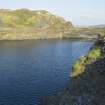
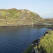
NGR NM 73552 17153
Datum OSGB36 - NGR
Permalink http://canmore.org.uk/site/354780


- Council Argyll And Bute
- Parish Kilbrandon And Kilchattan
- Former Region Strathclyde
- Former District Argyll And Bute
- Former County Argyll
Note (1989)
PWF Withall states that 'This is the largest of the complex of three [buildings] situated on the west side of the island and is named as the Engine House..there is no record of its origin or purpose, but it appears on the 1896 map of the island [J. Adams, 1974 based on the 2nd edition 25-inch Ordnance Survey map, Argyllshire, 1898, sheet CXXI.7] and is noted as 'Tigh Ensin Churrai', which is translated from the Gaelic as 'Currie's Engine House'.
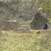
Within the building, there remains the sides of a pit together with a concrete base (measuring 2.6m in length by 1.52m in width) with holding down bolts embedded in the concrete (32mm in diameter, threaded). Adjacent is a much overgrown depression or pit measuring 2.3sq.m. This could indicate the site of a pump, now removed.. There are also remains of vertical metal pipe which apears to be some form of riser pipe with a horizontal pipe bracket nearby'.
Withall also states that it is said 'by some' that the engine was in fact a pump used to keep quarries NM71NW 116 and 117 dry. Following this line of thought he suggests that the motive power was by steam raised in the nearby building NM71NW 134 and carried by ducted pipes as there was no evidence of a boiler installation in the 'Engine House'. Withall admits that this may be unlikely as it would be an inefficient method of power. Alternatively a beam engine could have been employed lifting water using some form of inclined plane. Again the problem is the form that the motive power would have taken.
See National Record of the Historic Environment manuscript: MS8087/1, (1989) description and block survey drawings.
Field Visit (2015)
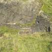
This is a ruinous, slate rubble built building similar in style to The Forge (NM71NW 132) and The Boiler House (NM71NW 134). The building consists of two compartments. Only the south east gable stands to any height, the rest of the walls having collapsed.
Visited by HES, Survey and Recording Section (MMD), September 2015.
Desk Based Assessment (2019)
This building, which is associated with NM71NW 132, 144, 134, 116 and 117, is depicted as roofed on the 2nd edition Ordnance Survey 25-inch map (Argyllshire, 1898, sheet CXXI.7). It is shown slightly east of the 'Old Quarry', NM71NW 116. It is still roofed and presumably in use by 1898 - it may have been associated with quarry NM71NW 117 which is shown in use in 1898. Tramlines are depicted connecting to NM71NW 134 and thence to the tramway skirting the east side of quarry NM71NW 117 and quarry NM71NW 118.
This building does not appear on the 1st edition of the Ordnance Survey 25-inch map (Argyllshire and Buteshire, (surveyed 1871) published 1872, sheet CXXI.7).
Withall (MS/8087/1) notes that the J. Adams, 1974 map (annotated version, based on the 2nd edition 25-inch Ordnance Survey map, Argyllshire, 1898, sheet CXXI.7) annotates this building as 'Tigh Ensin Churrai', which is translated from the Gaelic as 'Currie's Engine House'. Whithall does not explain the sources used by Adams from which this and other Easdale Gaelic names shown on the 1974 map were derived.
Information from HES Heritage Directorate, Survey and Recording Section, (MMD) 28 January 2019.

