
Pricing Change
New pricing for orders of material from this site will come into place shortly. Charges for supply of digital images, digitisation on demand, prints and licensing will be altered.
Boysack


Barrow(S) (Prehistoric), Linear Feature(S) (Period Unknown), Ring Ditch(S) (Prehistoric)(Possible), Square Barrow(S) (Iron Age), Unenclosed Settlement (Prehistoric)
Site Name Boysack
Classification Barrow(S) (Prehistoric), Linear Feature(S) (Period Unknown), Ring Ditch(S) (Prehistoric)(Possible), Square Barrow(S) (Iron Age), Unenclosed Settlement (Prehistoric)
Alternative Name(s) Invergighty Cottage
Canmore ID 35476
Site Number NO64NW 41
NGR NO 6174 4943
NGR Description Centred at NO 6174 4943
Datum OSGB36 - NGR
Permalink http://canmore.org.uk/site/35476


- Council Angus
- Parish Inverkeilor
- Former Region Tayside
- Former District Angus
- Former County Angus
Project (1 June 1976 - 31 August 1976)
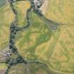
On the recommendation of the Committee for Rescue Archaeology set up by the Scottish Ancient Monuments Board a grant was made to the Commission in 1976 to allow it to carry out an extensive aerial survey programme. Climatic conditions during the period June-August were exceptionally favourable in much of eastern Scotland and more than 600 monuments were recorded, the majority being identified by means of crop-markings, a large number of which were new discoveries. The most interesting sites included Dark Age or Medieval timber halls on Deeside (NO 737967 [NO79NW 18], 733959 [NO79NW 16]) and west of Brechin (NO 509585 [NO55NW 40]); new Roman temporary camps at Ford, Midlothian (NT 384638 [NT36SE 18]) and Millside Wood [sic], Roxburghshire (NT 690270); double pit-alignments at Kinnell and Kinalty, Angus (NO 605494 [NO64NW 27], 356512 [NO35SE 32]); and a number of small, square-ditched enclosures, possibly barrows of the later Iron Age, in the Lunan valley, Angus (NO 626491 [NO64NW 95], 618494 [NO64NW 41] and 687509 [NO65SE 18]). A summary list of all these sites has been compiled and the prints will shortly be available for inspection in the National Monuments Record of Scotland.
RCAHMS (DES 1976, 84)
Note (March 1978)
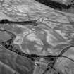
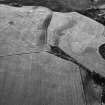
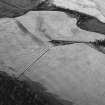
Boysack NO 618 494 NO64NW
Crop-marks showing the ditches of a number of circular and square barrows indicate the presence of a small cemetery on a broad terrace above an area of low-lying ground SW of lnvergighty Cottage. The cemetery includes at least two circular barrows measuring about 7m and 20m in diameter respectively, together with two contiguous, square barrows, each about 8m square and sharing one common side.
RCAHMS 1978, visited March 1978
Aerial Photographic Transcription (23 February 1992 - 6 March 1992)
An aerial transcription was produced from oblique aerial photographs. Information from Historic Environment Scotland (BM) 31 March 2017.

