 |
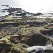
On-line Digital Images |
DP 228128 |
Records of the Royal Commission on the Ancient and Historical Monuments of Scotland (RCAHMS), Edinbu |
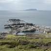
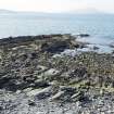
View of quarries NM71NW 118 (quarry Creag Rudbha Nam Faoileann) and NM71NW 119 (quarry on An Staca Dubh), general view from hill to north east |
7/9/2015 |
Item Level |
|
 |
On-line Digital Images |
DP 228129 |
Records of the Royal Commission on the Ancient and Historical Monuments of Scotland (RCAHMS), Edinbu |
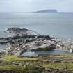
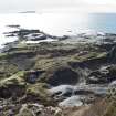
View of quarry NM71NW 118 and spoil (Creag Rudbha Nam Faoileann) and earlier quarrying activity NM71NW 119 beyond (An Staca Dubh), view from hill to north east |
7/9/2015 |
Item Level |
|
 |
On-line Digital Images |
DP 228132 |
Records of the Royal Commission on the Ancient and Historical Monuments of Scotland (RCAHMS), Edinbu |
Quarries NM71NW 117, 118 and 119.01 (An Lub Chlear, Fang and and Rudbha Nam Faoileann), and Klondye (NM71NW 120, foreground), view from hill to east |
7/9/2015 |
Item Level |
|
 |
On-line Digital Images |
DP 228133 |
Records of the Royal Commission on the Ancient and Historical Monuments of Scotland (RCAHMS), Edinbu |
Quarry NM71NW 118 (An Lub Chlear) and track, view from hill to east. Quarry NM71NW 120, 'Klondyke', right foreground |
7/9/2015 |
Item Level |
|
 |
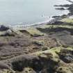
On-line Digital Images |
DP 228135 |
Records of the Royal Commission on the Ancient and Historical Monuments of Scotland (RCAHMS), Edinbu |
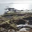
Quarries NM71NW 117 and 118 and 119 (An Lub Chlear, Fang and Rudbha Nam Faoileann/An Staca Dubh) and tramway track, spoil from the south west quarries and walls from view from hill to east |
7/9/2015 |
Item Level |
|
 |
On-line Digital Images |
DP 228172 |
Records of the Royal Commission on the Ancient and Historical Monuments of Scotland (RCAHMS), Edinbu |
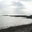
Beach to south of quarries NM71NW 118 and 119 (An Staca Dubh), view from east |
7/9/2015 |
Item Level |
|
 |
On-line Digital Images |
DP 228173 |
Records of the Royal Commission on the Ancient and Historical Monuments of Scotland (RCAHMS), Edinbu |
Beach to south of island, view from north |
7/9/2015 |
Item Level |
|
 |
On-line Digital Images |
DP 232638 |
Historic Environment Scotland |
West end of island, general view from high ground to east |
21/3/2016 |
Item Level |
|
 |
On-line Digital Images |
DP 232644 |
Historic Environment Scotland |
General view of west end of island from high ground to north east |
21/3/2016 |
Item Level |
|
 |
On-line Digital Images |
DP 232645 |
Historic Environment Scotland |
West end of island, view from high ground to north east |
21/3/2016 |
Item Level |
|
 |
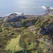
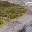
On-line Digital Images |
DP 232647 |
Historic Environment Scotland |
Garden enclosures to east of quarry NM71NW 118, view from high ground to north towards area centred on NM73595 17013 |
21/3/2016 |
Item Level |
|
 |
On-line Digital Images |
DP 264445 |
Historic Environment Scotland |
Oblique aerial view |
5/10/2017 |
Item Level |
|
 |
On-line Digital Images |
DP 264486 |
Historic Environment Scotland |
Oblique aerial view of south coastal quarry area, extreme south west tip of Easdale |
5/10/2017 |
Item Level |
|
 |
On-line Digital Images |
DP 264487 |
Historic Environment Scotland |
Oblique aerial view of Fang and An Lub Chlear quarries and south west area of Easdale |
5/10/2017 |
Item Level |
|
 |
On-line Digital Images |
DP 264488 |
Historic Environment Scotland |
Oblique aerial view south west area of Easdale |
5/10/2017 |
Item Level |
|
 |
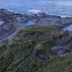
On-line Digital Images |
DP 264523 |
Historic Environment Scotland |
Oblique aerial view of Fang Quarry, a.k.a. Creag Rubha Nam Faoileann and the north portion of the the south coastal quarries |
4/10/2017 |
Item Level |
|
 |
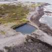
On-line Digital Images |
DP 264540 |
Historic Environment Scotland |
Oblique aerial view from north of Fang Quarry with some of its waste tipped into the south coastal quarries |
4/10/2017 |
Item Level |
|
 |
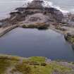
On-line Digital Images |
DP 264541 |
Historic Environment Scotland |
Oblique aerial view of Fang Quarry and some slate waste tipped into the south coastal quarry area. The ridge running down the centre of the south coastal quarries is clearly shown |
4/10/2017 |
Item Level |
|
 |
On-line Digital Images |
DP 264560 |
Historic Environment Scotland |
Oblique aerial view showing the general area which was known as the Camas Mor quarry area and slate waste heap NM71NW 149 |
4/10/2017 |
Item Level |
|
 |
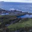
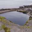
On-line Digital Images |
DP 264575 |
Historic Environment Scotland |
Oblique aerial view of south coastal quarries with the flooded Fang Quarry beyond |
4/10/2017 |
Item Level |
|
 |
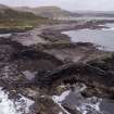
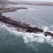
On-line Digital Images |
DP 264576 |
Historic Environment Scotland |
Oblique aerial view of coastal quarries from south |
4/10/2017 |
Item Level |
|
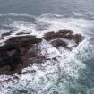 |
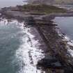
On-line Digital Images |
DP 264577 |
Historic Environment Scotland |
Oblique aerial view of southern tip of south coastal quarries, Rubha nam Faoileann |
4/10/2017 |
Item Level |
|
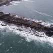 |
On-line Digital Images |
DP 264578 |
Historic Environment Scotland |
Oblique aerial view of Rubha nam Faoileann, south coastal quarries |
4/10/2017 |
Item Level |
|
 |
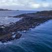
On-line Digital Images |
DP 264579 |
Historic Environment Scotland |
Oblique aerial view of south coastal quarries |
4/10/2017 |
Item Level |
|


