Accessibility

Font Size

100% 150% 200%

Background Colour

Default Contrast
Close Reset

Easdale, South Coastal Quarries

Slate Quarry(S) (18th Century)

Site Name Easdale, South Coastal Quarries

Classification Slate Quarry(S) (18th Century)

Alternative Name(s) Rubha Nam Faoileann; An Staca Dubh

Canmore ID 353997

Site Number NM71NW 119.01

NGR NM 73384 16856

Datum OSGB36 - NGR

Permalink http://canmore.org.uk/site/353997

Ordnance Survey licence number AC0000807262. All rights reserved.
Canmore Disclaimer. © Bluesky International Limited 2025. Public Sector Viewing Terms

Toggle Aerial | View on large map

Digital Images

View of quarry NM71NW 118 and spoil (Creag Rudbha Nam Faoileann) and earlier quarrying activity NM71NW 119 beyond (An Staca Dubh), view from hill to north east
View of quarry NM71NW 118 and spoil (Creag Rudbha Nam Faoileann) and earlier quarrying activity NM71NW 119 beyond (An Staca Dubh), view from hill to north eastOblique aerial view of Fang Quarry, a.k.a. Creag Rubha Nam Faoileann and the north portion of the the south coastal quarriesOblique aerial view of Rubha nam Faoileann, south coastal quarriesWest end of island, general view from high ground to eastWest end of island, view from high ground to north eastOblique aerial viewOblique aerial view of coastal quarries from southOblique aerial view of Rubha nam Faoileann, south coastal quarriesOblique aerial view of Rubha nam Faoileann, south coastal quarriesQuarries NM71NW 117, 118 and 119.01 (An Lub Chlear, Fang and and Rudbha Nam Faoileann), and Klondye (NM71NW 120, foreground), view from hill to eastOblique aerial view of Fang and An Lub Chlear quarries and south west area of EasdaleOblique aerial view from north of Fang Quarry with some of its waste tipped into the south coastal quarriesOblique aerial view of Fang Quarry and some slate waste tipped into the south coastal quarry area. The  ridge running down the centre of the south coastal quarries is clearly shownOblique aerial view of southern tip of south coastal quarries, Rubha nam FaoileannBeach to south of quarries NM71NW 118 and 119 (An Staca Dubh), view from eastOblique aerial view from south west of Fang Quarry area and quarrying at south coastal quarriesGeneral view of west end of island from high ground to north eastGarden enclosures to east of quarry NM71NW 118, view from high ground to north towards area centred on NM73595 17013Oblique aerial view of south coastal quarry area, extreme south west tip of EasdaleOblique aerial view south west area of EasdaleOblique aerial view showing the general area which was known as the Camas Mor quarry area and slate waste heap NM71NW 149Oblique aerial view of Rubha nam Faoileann, south coastal quarriesOblique aerial view from north east of south coastal quarriesView of quarries NM71NW 118 (quarry Creag Rudbha Nam Faoileann) and NM71NW 119 (quarry on An Staca Dubh), general view from hill to north eastBeach to south of island, view from northOblique aerial view of Rubha nam Faoileann, south coastal quarriesOblique aerial view from south west of south coastal quarries and Fang Quarry (in background)Quarry NM71NW 118 (An Lub Chlear) and track, view from hill to east. Quarry NM71NW 120, 'Klondyke', right foregroundQuarries NM71NW 117 and 118 and 119 (An Lub Chlear, Fang and Rudbha Nam Faoileann/An Staca Dubh) and tramway track, spoil from the south west quarries and walls from view from hill to eastOblique aerial view of south coastal quarries with the flooded Fang Quarry beyondOblique aerial view of south coastal quarriesOblique aerial view of quarried out slate

Administrative Areas

  • Council Argyll And Bute
  • Parish Kilbrandon And Kilchattan
  • Former Region Strathclyde
  • Former District Argyll And Bute
  • Former County Argyll

Activities

Desk Based Assessment (8 November 2019)

Quarries

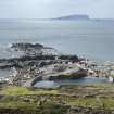
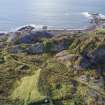
Large scale, concentrated exploitation of the Easdale slate belt began in earnest in the mid-18th century by the landowner, the 2nd Earl of Breadalbane. Slate production reached its height in the 1860s. Commercial

quarrying on Easdale (and the other islands) had ceased by the First World War (1914) with the bankruptcy of the Easdale Slate Quarries Company in 1911. The slate the Welsh slate industry. Today, there are no quarries in

Scotland producing roofing slate.

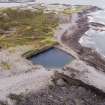
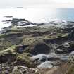
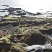
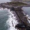
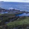
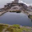
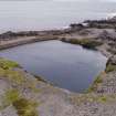
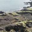
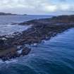
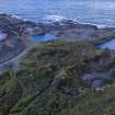
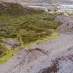
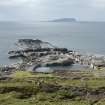
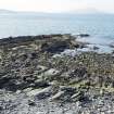
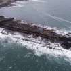
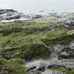
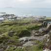
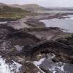
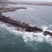
There is also evidence of early shoreline quarrying which would have predated and partially continued when the deeper quarries were dug inland during the latter 18th century. Eighteen areas of quarrying were identified during fieldwork. Some are known to have existed in the 18th century, others only appear on maps with little information known other that they were abandoned or closed by a certain date. Others were reopened and reused when the construction industry picked up again and roof tiles were in demand.

Information from Miriam McDonald, Survey and Recording Section, Heritage Directorate, HES, 08/11/2019.

References

MyCanmore Image Contributions


Contribute an Image

MyCanmore Text Contributions