 |
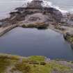
On-line Digital Images |
DP 232701 |
Historic Environment Scotland |
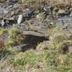
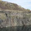
Walled enclosure and remains of quarry working stuctures(NM71NW 118.02) to north east of Quarry (NM71NW 118.00) at NM7330 17011, detail of opening with lintel |
21/3/2016 |
Item Level |
|
 |
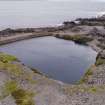
On-line Digital Images |
DP 232702 |
Historic Environment Scotland |
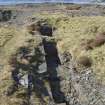
View from south, Sunken structure, possibly pump house remains (NM71MNW 118.02) to north east of Fang Quarry (NM71NW 118.00) |
21/3/2016 |
Item Level |
|
 |
On-line Digital Images |
DP 232703 |
Historic Environment Scotland |
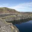
Quarry (NM71NW 118.00), view from west. Remains of quarry buildings (NM71MNW 118.02) |
21/3/2016 |
Item Level |
|
 |
On-line Digital Images |
DP 232704 |
Historic Environment Scotland |
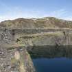
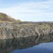
Quarry (NM71NW 118.00), north east face, view from west. Remains of quarry buildings (NM71MNW 118.02) and retaining wall, strengthening the working platform and building platform above. |
21/3/2016 |
Item Level |
|
 |
On-line Digital Images |
DP 232705 |
Historic Environment Scotland |
Quarry (NM71NW 118.00), detail of stonework remains of quarry buildings on north east face (NM71NW 118.02) |
21/3/2016 |
Item Level |
|
 |
On-line Digital Images |
DP 232706 |
Historic Environment Scotland |
Quarry (NM71NW 118.00), north east face, view from west. Remains of quarry buildings (NM71MNW 118.02) |
21/3/2016 |
Item Level |
|
 |
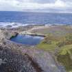
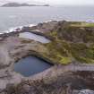
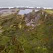
On-line Digital Images |
DP 264448 |
Historic Environment Scotland |
Oblique aerial view showing the quarries Fang, An lub chlear, An Toll mar Luaty and Klondyke (dry). These all post date 1871 and pre-date 1898. |
5/10/2017 |
Item Level |
|
 |
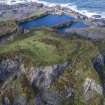
On-line Digital Images |
DP 264451 |
Historic Environment Scotland |
Oblique aerial view from south east showing Klondyke Quarry (right) with An Lub Chlear and An Toll mar Luaty quarries beyond, Fang Quarry (left) and walled garden enclosures which pre-date the quarries in this area. |
5/10/2017 |
Item Level |
|
 |
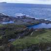
On-line Digital Images |
DP 264452 |
Historic Environment Scotland |
Oblique aerial view shwping Fang and An Lub Chlear quarries. A tramway (NM71NW 127.02) is also visible in the image (right foreground). |
5/10/2017 |
Item Level |
|
 |
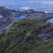
On-line Digital Images |
DP 264469 |
Historic Environment Scotland |
Oblique aerial view of east end of Easdale showing Doune Quarry (foreground), Hill Quarry (right), An Toll Mar Luaty Quarry with later slate waste dumped into it, An Dub Chlear Quarry, and Fang Quarry (top left) |
5/10/2017 |
Item Level |
|
 |
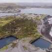
On-line Digital Images |
DP 264487 |
Historic Environment Scotland |
Oblique aerial view of Fang and An Lub Chlear quarries and south west area of Easdale |
5/10/2017 |
Item Level |
|
 |
On-line Digital Images |
DP 264488 |
Historic Environment Scotland |
Oblique aerial view south west area of Easdale |
5/10/2017 |
Item Level |
|
 |
On-line Digital Images |
DP 264489 |
Historic Environment Scotland |
Oblique aerial view of west quarries |
5/10/2017 |
Item Level |
|
 |
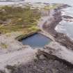
On-line Digital Images |
DP 264501 |
Historic Environment Scotland |
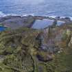
Oblique aerial view showing slate waste, the flooded Fang Quarry and garden enclosures and tramways around NM73553 17019 |
5/10/2017 |
Item Level |
|
 |
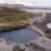
On-line Digital Images |
DP 264523 |
Historic Environment Scotland |
Oblique aerial view of Fang Quarry, a.k.a. Creag Rubha Nam Faoileann and the north portion of the the south coastal quarries |
4/10/2017 |
Item Level |
|
 |
On-line Digital Images |
DP 264535 |
Historic Environment Scotland |
Oblique aerial view of Fang quarry (also known as Creag Rubha Nam Faoileann) with Camas Mor area behind |
4/10/2017 |
Item Level |
|
 |
On-line Digital Images |
DP 264537 |
Historic Environment Scotland |
Oblique aerial view of Fang and An Lub Chlear quarries |
4/10/2017 |
Item Level |
|
 |
On-line Digital Images |
DP 264540 |
Historic Environment Scotland |
Oblique aerial view from north of Fang Quarry with some of its waste tipped into the south coastal quarries |
4/10/2017 |
Item Level |
|
 |
On-line Digital Images |
DP 264541 |
Historic Environment Scotland |
Oblique aerial view of Fang Quarry and some slate waste tipped into the south coastal quarry area. The ridge running down the centre of the south coastal quarries is clearly shown |
4/10/2017 |
Item Level |
|
 |
On-line Digital Images |
DP 264546 |
Historic Environment Scotland |
Oblique aerial view of the west end of the island |
4/10/2017 |
Item Level |
|
 |
On-line Digital Images |
DP 264548 |
Historic Environment Scotland |
Oblique aerial view of the south western part of the island. The ridge running down the centre of the west of the island can be clearly seen , with quarries either side. |
4/10/2017 |
Item Level |
|
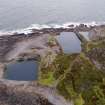 |
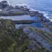
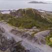
On-line Digital Images |
DP 264553 |
Historic Environment Scotland |
Oblique aerial view from north east showing flooded quarries Fang, Klondyke, An Lub Chlear and An Toll Mar Luaty |
4/10/2017 |
Item Level |
|
 |
On-line Digital Images |
DP 264554 |
Historic Environment Scotland |
Oblique aerial view from west with Fang and An Lub Chlear quarries nearest the camra |
4/10/2017 |
Item Level |
|
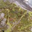 |
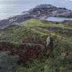
On-line Digital Images |
DP 264559 |
Historic Environment Scotland |
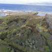
Oblique aerial view of garden enclosures and tramways at the south west part of Easdale Island adjacent to Fang Quarry |
4/10/2017 |
Item Level |
|


