
Pricing Change
New pricing for orders of material from this site will come into place shortly. Charges for supply of digital images, digitisation on demand, prints and licensing will be altered.
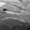
Newbarns


Enclosure (Medieval) - (Post Medieval)
Site Name Newbarns
Classification Enclosure (Medieval) - (Post Medieval)
Canmore ID 35393
Site Number NO64NE 17
NGR NO 68380 49340
Datum OSGB36 - NGR
Permalink http://canmore.org.uk/site/35393


- Council Angus
- Parish Inverkeilor
- Former Region Tayside
- Former District Angus
- Former County Angus
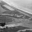
NO 680 490 (centre) A programme of trial trenching was carried out on adjoining fields, one Scheduled and one unscheduled, to the N of Newbarns Farm.
A trench was opened over the NE corner of a rectilinear enclosure (NO64NE 17) measuring c 30 x 30m. A break in the ditch defining the enclosure formed the only visible entrance. The ditch was 1.35m wide and 0.5m deep. A line of small post-holes was visible c 1.2m inside the ditch, possibly indicating the presence of a retaining revetment wall for an upcast bank. Inside the excavated part of the enclosure, three pits were arranged in a semi-circle. Outside the enclosure were several post-holes. There were no finds from this trench.
A detailed report will be lodged with the NMRS.
Sponsors: Historic Scotland, University of Edinburgh.
C McGill 1998
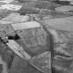
NO 683 492 The second season of a programme of trial trenching was carried out to the W of Newbarns Farm (McGill 1998). The field is rich in cropmarks of varying forms, some of which are Scheduled.
Eleven trenches were excavated: three within the Scheduled area and eight outside it. Of this total, only two trenches were devoid of archaeological features.
The excavated features comprised pits, linear ditches, natural ice wedges, a truncated ring-ditch house, a sub-rectangular enclosure (possibly a Dark Age timber hall), and a possible square barrow. No features produced any artefactual dating evidence, and provisional dates can only be applied to three feature groups (the ring-ditch house, timber hall and square barrow-type feature) on the basis of their morphology. The results supported the conclusions from the previous year's work at Newbarns that the clarity of cropmarks is the result of a combination of topography, ploughsoil depth, subsoil, feature depth, size and nature of fill, with the principal deciding factor being geomorphological considerations. There was considerable evidence across the site for plough-scoring of subsoil and features, suggesting that active truncation is occurring.
A detailed report will be lodged with NMRS.
Sponsors: Historic Scotland, University of Edinburgh.
C McGill 1999
Field Visit (March 1978)
New Barns 1 NO 683 493 NO64NE
In a field N of New Barns, the crop-mark of an enclosure, which measures about 30m square, has been recorded.
RCAHMS 1978, visited March 1978
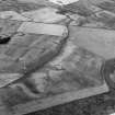
Aerial Photographic Transcription (24 February 1994 - 21 April 1994)
An aerial transcription was produced from oblique aerial photographs. Information from Historic Environment Scotland (BM) 31 March 2017.

