
Eigg, Howlin


Building(S) (19th Century), Building Platform (20th Century), Cottage (20th Century), Enclosure(S) (19th Century), Stack Stand(S) (19th Century), Township (19th Century)
Site Name Eigg, Howlin
Classification Building(S) (19th Century), Building Platform (20th Century), Cottage (20th Century), Enclosure(S) (19th Century), Stack Stand(S) (19th Century), Township (19th Century)
Canmore ID 352603
Site Number NM48NE 121
NGR NM 4795 8940
Datum OSGB36 - NGR
Permalink http://canmore.org.uk/site/352603


- Council Highland
- Parish Small Isles
- Former Region Highland
- Former District Lochaber
- Former County Inverness-shire
Field Visit (5 June 2001)
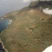
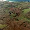
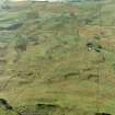
The remains of the township of Howlin are situated to the S and SW of Howlin Cottage, a roofed and occupied building which probably incorporates an earlier structure. In addition to the Cottage, the township comprises at least six buildings and two enclosures. The buildings are sub-rectangular on plan with rubble faced walls and exhibit both rounded and squared corners. Most show some signs of alteration and many have been partially robbed.
Situated 28m SW of the cottage, the largest building (110) measures 8.1m from NW to SE by 2.8m transversely within a wall 0.6m in thickness and 0.9m in height. It is separated into two rooms and has a single entrance in the NE wall. Some 15m to the SE another building (111) is attached to an enclosure within which there are three stone stack stands. Another building (112) is attached to the S end of the cottage and it seems possible that they once formed a single range. Two further small buildings (113-4) stand to the S and SE of 112.
A outlying building of the same character (115) stands 75m ENE of the cottage. There is also a much later concrete building platform (109), probably the footings of a shed, 65m to the SW of the Cottage. A spring (116) protected by a concrete wall stands 55m WNW of the cottage on the opposite side of the road, and there is another 30m to its S.
The settlement and farmland is shown in some detail on Bald’s map of 1806, and an outline of its history is provided in recent summaries of the island’s story (Wade Martins 2004 edn, Dressler 1998). The cottage, four buildings (110-3) and an additional building 10m NE of the cottage are shown roofed on the on the 1st edition of the OS 6-inch map (Inverness-shire (Skye) Sheet LXXI, 1879). Another building (114) is shown unroofed.
EIGG01 109-116
Visited by RCAHMS (AGCH) 5 June 2001.
See also NM48NE 31

