
Traprain Law


Building(S) (19th Century) - (20th Century), Quarry (19th Century) - (20th Century)
Site Name Traprain Law
Classification Building(S) (19th Century) - (20th Century), Quarry (19th Century) - (20th Century)
Canmore ID 352330
Site Number NT57SE 171
NGR NT 5839 7495
Datum OSGB36 - NGR
Permalink http://canmore.org.uk/site/352330


- Council East Lothian
- Parish Prestonkirk
- Former Region Lothian
- Former District East Lothian
- Former County East Lothian
Field Visit (20 June 2018)
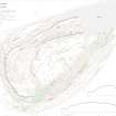
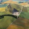
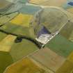
The large quarry that removed much of the NE end of Traprain Law closed in 1975 (Hunter 2003, 252) and only vestiges of the tracks and buildings that serviced it remain. At its maximum extent, the quarry measured about 240m from ENE to WSW by about 145m transversely and the face at the rear rises to about 45m, the total depth of the quarry being about 70m.
The quarry was considerably smaller when it was depicted on the 1st edition of the OS 6-inch map (Haddingtonshire 1855, sheet 10), annotated as a sandstone quarry, and it was accessed at that time from the NE by two tracks. Successive editions of the OS 25-inch map show the expansion of the quarry during the later 19th and early 20th centuries (Haddingtonshire 1894 and 1907, sheet 11.1). By 1907 three small buildings serviced the quarry; one at the gate (NT 5848 7504); another near the quarry’s centre (NT 5834 7497); and a third constructed as a magazine 150m to the W (NT57SE 171).
When the quarry was captured on a vertical aerial photograph in 1946, it had expanded to a much larger size and a complex of processing buildings had been constructed in the NW corner of the site, on both sides of the public road (NCAP: 106G/Scot/UK/0014, 7258). Oblique aerial photographs taken by John Dewar in 1967 and 1972 show the quarry and its infrastructure in some detail prior to closure (e.g HES: SC1549004, SC370940). The remains of a track and traces of buildings are visible in an overgrown area immediately W of the quarry and S of the public road, but the sites of other buildings are now occupied by a car park and an electricity sub-station.
Visited by HES (GFG, AM) 20 June 2018.
(TPR22)

