Accessibility

Font Size

100% 150% 200%

Background Colour

Default Contrast
Close Reset

Brechin, General

Burgh (Medieval), Town (Medieval) - (Post Medieval)

Site Name Brechin, General

Classification Burgh (Medieval), Town (Medieval) - (Post Medieval)

Canmore ID 35090

Site Number NO56SE 40

NGR NO 59 60

NGR Description NO c. 59 60

Datum OSGB36 - NGR

Permalink http://canmore.org.uk/site/35090

Ordnance Survey licence number AC0000807262. All rights reserved.
Canmore Disclaimer. © Bluesky International Limited 2025. Public Sector Viewing Terms

Toggle Aerial | View on large map

Digital Images

General oblique aerial view of the Skinner's Burn area of Brechin, centred on Brechin Cathedral, taken from the NW.
General oblique aerial view of the Skinner's Burn area of Brechin, centred on Brechin Cathedral, taken from the NW.General oblique aerial view of the Skinner's Burn area of Brechin, centred on Brechin Cathedral, taken from the NNW.General oblique aerial view of Panmure Street area of Brechin, centred on West and St. Columba's Parish Church, taken from the NNE.General oblique aerial view of Panmure Street area of Brechin, centred on West and St. Columba's Parish Church, taken from the NNW.General oblique aerial view of Panmure Street area of Brechin, centred on West and St. Columba's Parish Church, taken from the WNW.General oblique aerial view of Panmure Street area of Brechin, centred on West and St. Columba's Parish Church, taken from the WSW.General oblique aerial view of Brechin Railway Terminus, centred the ticket office, taken from the SW.General oblique aerial view of St. Andrew Street, Brechin, centred the St. Andrew's Episcopal Church, taken from the W.Oblique aerial view.Aerial view.Aerial view.Oblique aerial view.Oblique aerial view.Aerial view.Aerial view.Aerial view.General view.
Inscribed at top: "High Street and Town Hall of Brechin".
Inscribed at bottom: "Church Street, Having Mechanics' Hall in the Distance".Scanned image of oblique aerial photograph centred on the town, taken from the S.General oblique aerial view of the centre of Brechin, centred on the High Street, taken from the NNE.General oblique aerial view of Panmure Street area of Brechin, centred on West and St. Columba's Parish Church, taken from the NW.General oblique aerial view of Brechin Railway Terminus, centred the ticket office, taken from the E.Oblique aerial view.Aerial view.Brechin, General, NO56SE 40, Ordnance Survey index card, RectoHistoric photographic view.General oblique aerial view of the Skinner's Burn area of Brechin, centred on Brechin Cathedral, taken from the SSW.General oblique aerial view of the Skinner's Burn area of Brechin, centred on Brechin Cathedral, taken from the NW.General oblique aerial view of the centre of Brechin, centred on the High Street, taken from the WSW.General oblique aerial view of Panmure Street area of Brechin, centred on West and St. Columba's Parish Church, taken from the SE.General oblique aerial view of Damacre Road, Brechin, centred the Gardner Memorial Church, taken from the E.Oblique aerial view.Oblique aerial view.Aerial view.Oblique aerial view.Historic photographic view from S.General oblique aerial view of the Skinner's Burn area of Brechin, centred on Brechin Cathedral, taken from the SW.General oblique aerial view of the Skinner's Burn area of Brechin, centred on Brechin Cathedral, taken from the NE.General oblique aerial view of the centre of Brechin, centred on the High Street, taken from the NW.General oblique aerial view of Panmure Street area of Brechin, centred on West and St. Columba's Parish Church, taken from the SE.General oblique aerial view of Brechin Railway Terminus, centred the ticket office, taken from the NNE.General oblique aerial view of St. Andrew Street, Brechin, centred the St. Andrew's Episcopal Church, taken from the E.Oblique aerial view.Aerial view.Aerial view.Photographic copy of engraved view of Brechin from Theatrum Scotiae by John Slezer.General view.General oblique aerial view of the Skinner's Burn area of Brechin, centred on Brechin Cathedral, taken from the E.General oblique aerial view of the centre of Brechin, centred on the High Street, taken from the E.General oblique aerial view of Brechin Railway Terminus, centred the ticket office, taken from the S.Pl.53 Brechin. Copy of copper plate engraving titled 'Prospectus Oppidi Brechinae. The prospect of ye Towne of Brechin. This plate is most humbly inscribed to the Honble Collonll John Campbel.'Brechin, copy of engraved view after Slezer plate 53.General oblique aerial view of Strathmore, centred on Courthill.Aerial view.Oblique aerial view.Oblique aerial view.Oblique aerial view.Aerial view.General oblique aerial view of the Skinner's Burn area of Brechin, centred on Brechin Cathedral, taken from the W.General oblique aerial view of the centre of Brechin, centred on the High Street, taken from the SW.General oblique aerial view of the centre of Brechin, centred on the High Street, taken from the SSE.General oblique aerial view of Brechin Railway Terminus, centred the ticket office, taken from the SE.General oblique aerial view of St. Andrew Street, Brechin, centred the St. Andrew's Episcopal Church, taken from the S.Oblique aerial view.Oblique aerial view.Oblique aerial view.Oblique aerial view.Aerial view.Aerial view.Scanned image of an oblique aerial view centred on the town, taken from the SW.General oblique aerial view of the Skinner's Burn area of Brechin, centred on Brechin Cathedral, taken from the ENE.General oblique aerial view of Panmure Street area of Brechin, centred on West and St. Columba's Parish Church, taken from the S.General oblique aerial view of Brechin Railway Terminus, centred the ticket office, taken from the W.Aerial view.Oblique aerial view.Aerial view.Oblique aerial view.Aerial view.Oblique aerial view.Aerial view.General oblique aerial view of the Skinner's Burn area of Brechin, centred on Brechin Cathedral, taken from the SE.General oblique aerial view of the centre of Brechin, centred on the High Street, taken from the ESE.General oblique aerial view of Damacre Road, Brechin, centred the Gardner Memorial Church, taken from the SSE.General oblique aerial view of Brechin Railway Terminus, centred the ticket office, taken from the N.General oblique aerial view of St. Andrew Street, Brechin, centred the St. Andrew's Episcopal Church, taken from the SW.Oblique aerial view.

Administrative Areas

  • Council Angus
  • Parish Brechin
  • Former Region Tayside
  • Former District Angus
  • Former County Angus

Architecture Notes

NO56SE 40 59 60

NMRS REFERENCE

O'Brian sketches - pencil view.

EXTERNAL REFERENCES

Scottish National Portrait Gallery, SMT Magazine, December 1952 - article and photographs (Mechanics' Institute, Cathedral and Tower)

Public Library (Scottish Room) Guides to Brechin - texts.

Activities

Note (1984)

Brechin NO c. 59 60 NO56SE

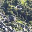
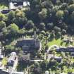
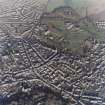
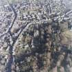
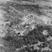
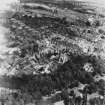
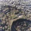
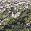
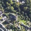
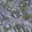
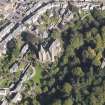
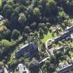
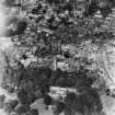
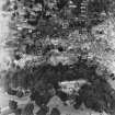
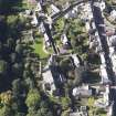
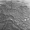
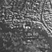
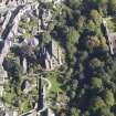
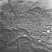
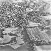
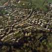
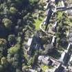
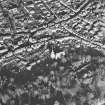
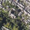
A religious community was established at Brech in by the 10th century and in the reign of David I ( 1124-53) the bishop and culdees of Brech in were granted the right to hold a market. The town was a free burgh belonging to the bishop, but gradually came to be regarded as a royal burgh. Surviving medieval buildings are the cathedral, the round tower and a fragment of the hospital of Maison Dieu.

RCAHMS 1984.

(Pryde 1965, p. 33, no. 77 and p. 38, no. 87; SBS Brechin).

References

MyCanmore Image Contributions


Contribute an Image

MyCanmore Text Contributions