
White Caterthun


Unenclosed Settlement (Prehistoric)
Site Name White Caterthun
Classification Unenclosed Settlement (Prehistoric)
Canmore ID 35036
Site Number NO56NW 43
NGR NO 5489 6601
Datum OSGB36 - NGR
Permalink http://canmore.org.uk/site/35036


- Council Angus
- Parish Menmuir
- Former Region Tayside
- Former District Angus
- Former County Angus
Note (1983)
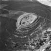
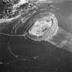
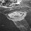
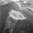
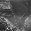
White Caterthun 2 NO 549 660 to NO 550 661 NO56NW 43
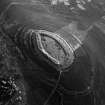
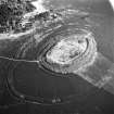
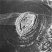
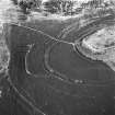
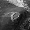
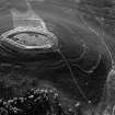
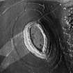
On the E side of the White Caterthun, immediately outside the outer rampart of the fort (NO56NW 17), there are at least two ring-ditch houses; a third house is situated about 160m to the ENE, a short distance to the N of the footpath leading to the fort.
RCAHMS 1983.
(DES, 1980, 37).
Field Visit (29 September 1989)
NO56NW 43.00 549 660 to 550 661
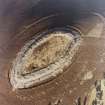
NO56NW 43.01 NO 5489 6601 Ring-ditch House
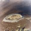
NO56NW 43.02 NO 5491 6605 Ring-ditch House
Two ring-ditch houses are situated immediately below the outermost ramparts on the E side of the White Caterthun fort (NO56NW 17). At least one other lies to the NE (NO 56NE 32.1) and another is situated within the fort.
Visited by RCAHMS (SH) 29 September 1989.

