
Following the launch of trove.scot in February 2025 we are now planning the retiral of some of our webservices. Canmore will be switched off on 24th June 2025. Information about the closure can be found on the HES website: Retiral of HES web services | Historic Environment Scotland
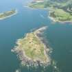
Barlocco Isle


Clearance Cairn(S) (Period Unassigned), Field Boundary(S) (Period Unassigned), Rig And Furrow (Medieval) - (Post Medieval)
Site Name Barlocco Isle
Classification Clearance Cairn(S) (Period Unassigned), Field Boundary(S) (Period Unassigned), Rig And Furrow (Medieval) - (Post Medieval)
Canmore ID 346479
Site Number NX54NE 21
NGR NX 5777 4817
Datum OSGB36 - NGR
Permalink http://canmore.org.uk/site/346479


- Council Dumfries And Galloway
- Parish Borgue
- Former Region Dumfries And Galloway
- Former District Stewartry
- Former County Kirkcudbrightshire

