
Following the launch of trove.scot in February 2025 we are now planning the retiral of some of our webservices. Canmore will be switched off on 24th June 2025. Information about the closure can be found on the HES website: Retiral of HES web services | Historic Environment Scotland
Alvie Home Farm


Cultivation Terrace(S) (Period Unassigned), Hut Circle(S) (Prehistoric)
Site Name Alvie Home Farm
Classification Cultivation Terrace(S) (Period Unassigned), Hut Circle(S) (Prehistoric)
Canmore ID 346151
Site Number NH80NW 66
NGR NH 83476 07794
Datum OSGB36 - NGR
Permalink http://canmore.org.uk/site/346151


- Council Highland
- Parish Alvie
- Former Region Highland
- Former District Badenoch And Strathspey
- Former County Inverness-shire
Field Visit (21 February 2012)
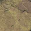
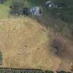
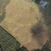
Three hut circles were identified in rough pasture on the hillside above Alvie Gardens. The first (NH83448 07927) measures about 8m in diameter within a low stony bank spread to about 1.8m in thickness. The hut has been set into the slope on the NW and a gap in the bank suggests that the entrance was on the ESE. A second (NH 83396 07880), 65m to the SW, stands between a trackway to the SW and cultivated ground to the E and NE. It measures 8.5m in diameter within a grass- and bracken-grown stony bank up to 0.3m high and 1.8m thick. It is set into gently rising ground on the NW. The bank is badly denuded on the SE, but the entrance is presumably in that quadrant. A third hut circle (NH 83381 07832), situated 50m further to the SSW, is set into the slope on the NW. It measures 9.7m in diameter within a grass-grown stony bank up to 1.6m thick and 0.4m high (up to 0.8m high at the back scarp in the NW) with an entrance on the ESE.
Visited by RCAHMS (SDB, AG) 21 February 2012
Aerial (14 April 2014)

