
Following the launch of trove.scot in February 2025 we are now planning the retiral of some of our webservices. Canmore will be switched off on 24th June 2025. Information about the closure can be found on the HES website: Retiral of HES web services | Historic Environment Scotland
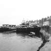
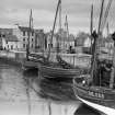
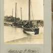
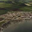
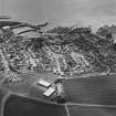
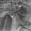
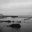
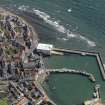
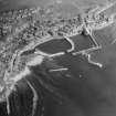
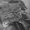
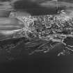
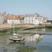
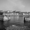
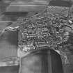
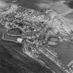
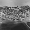
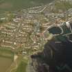
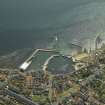
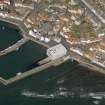
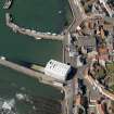
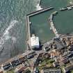
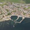
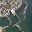
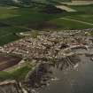
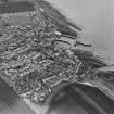
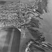
St Monance, East Shore, Harbour


Harbour (19th Century)
Site Name St Monance, East Shore, Harbour
Classification Harbour (19th Century)
Alternative Name(s) St Monans Harbour; Firth Of Forth; Outer Forth Estuary
Canmore ID 34278
Site Number NO50SW 81
NGR NO 52606 01567
NGR Description Centred NO 52606 01567
Datum OSGB36 - NGR
Permalink http://canmore.org.uk/site/34278


- Council Fife
- Parish St Monance
- Former Region Fife
- Former District North East Fife
- Former County Fife
NO50SW 81.00 centred 52606 01567
Harbour [NAT]
Piers [NAT]
OS 1:10,000 map, 1994.
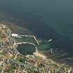
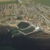
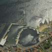
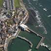
NO50SW 81.01 NO 52575 01534 to NO c. 52535 01548 West Pier
NO50SW 81.02 NO 52588 01535 to NO 52610 01537 to NO c. 52646 01614 Central Pier
NO50SW 81.03 NO 52586 01511 to NO 52668 01500 to NO c. 52733 01612 East Pier
NO50SW 81.04 NO 52597 01420 to NO c. 56617 01500 East Pier Extension (Breakwater)
NO50SW 81.05 NO 52498 01479 to NO 52533 01462 Detached West Breakwater
NO50SW 81.06 NO 52701 01493 to NO 52750 01514 Detached East Breakwater
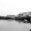
NO50SW 81.07 NO 52584 01589 West Basin
NO50SW 81.08 NO 52667 01554 East Basin
NO50SW 81.09 NO 52618 01625 Slipway
NO50SW 81.10 NO 52534 01419 Detached beacon
NO50SW 81.11 NO c. 52596 01422 East Breakwater Extension, Beacon
NO50SW 81.12 NO c. 52575 01533 West Pier, Beacon
NO50SW 81.13 NO c. 52591 01534 Central Pier, Beacon
NO50SW 81.14 NO c. 52588 01510 East Pier, Beacon
For integral boatbuilding yard (James N Miller and Sons), see NO50SW 290.00.
Not to be confused with possible landing-place at West [St] Monance (NO c. 523 014), for which see NO50SW 479.
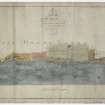
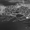
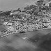
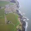
(Location cited as NO 525 015). St Monance, Fife. It appears from a charter of 1596 that the then laird of St Monance had been at great expense 'pro constructione portus juxta lituis maris apud dictam villam', but it would be unsafe to treat the word 'constructione' as proof that this was new work rather than the repair of something which already existed. Two subsequent charters, of 1650 and 1661, which grant powers 'portum et navium stationem edificandi' and a Privy Council order of 1671, which authorises the collection of money for the building of a 'harbour or bulwark' might seem at variance with the charter of 1596 as suggesting that the place still lacked harbour-works at the dates in question, but again too much should not be made of what may be no more than legal formulae. It may be concluded, therefore, that harbour-works of some kind had existed since at least the later 16th century, although whether they constituted the 'port' of 1565, which may or may not have been improved, or whether they were sited, as at present, in front of the town, or was the 'port' of 1649, at West St Monance [NO50SW 479] ie. in the mouth of the St Monance Burn, remains an open question.
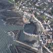
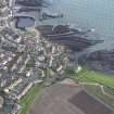
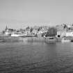
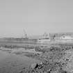
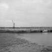
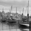
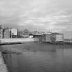
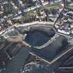
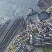
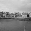
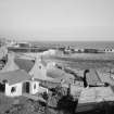
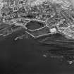
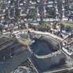
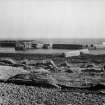
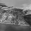
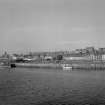
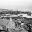
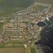
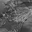
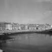
Today, the structures in the harbour all post-date the first Ordnance survey of 1854, apart from the pier (NO50SW 81.02) that separates the E and W basins, and even this has been covered with cement which hides all structural evidence bearing on its origin. Only the general outline of the earlier haven survives, and this indicates a tidal basin enclosed on the E and SE by the pier, on the N by the land, and on the W by tidal rocks; the entrance is on the S, between the pier-head and a projecting rock-ridge which now carries a modern pier. The main part of the earlier pier is about 300ft [91.5m] long, and is aligned slightly W of S, the pier-head, 63ft [19.2m] long, diverging westwards to form the E side of the entrance. This arrangement appears to correspond with that shown on Roy's map of Scotland (1747-55) and also with Adair's (1703) 'Creek with a Key for small Vessels and Boats'. The harbour was rebuilt in or about 1883, the rock being excavated and the entrance widened on account of the increasing size of fishing boats. The cut-back rock may be seen under the facing-wall that supports the West Shore, and in the NW corner of the basin. The facing-wall shows masonry of various types, which no doubt reflect repairs, rebuilding and the re-use of old material of deceptively weathered appearance.
A Graham 1971.
(Location cited as NO 526 015). St Monans Harbour, rebuilt 1865 and c.1883. Two basins formed by 3 L-plan piers, part concrete, part masonry of various dates.
J R Hume 1976.
Structures outside St Monance Harbour. These are definitely related to Harbour. Visible on vertical air photographs (Fairey Surveys Ltd SDD Coastal Strip).
Site recorded by Maritime Fife during the Coastal Assessment Survey for Historic Scotland, Kincardine to Fife Ness 1996.
Photographic Survey (September 1963)
Photographic survey of buildings in St Monance, Fife, by the Ministry of Work/Scottish National Buildings Record in September 1963.

