
Following the launch of trove.scot in February 2025 we are now planning the retiral of some of our webservices. Canmore will be switched off on 24th June 2025. Information about the closure can be found on the HES website: Retiral of HES web services | Historic Environment Scotland
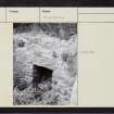
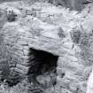
St Monan's Cell


Cave (Period Unassigned)
Site Name St Monan's Cell
Classification Cave (Period Unassigned)
Alternative Name(s) St Monance; St Monan's Stedd
Canmore ID 34197
Site Number NO50SW 11
NGR NO 5231 0147
Datum OSGB36 - NGR
Permalink http://canmore.org.uk/site/34197


- Council Fife
- Parish St Monance
- Former Region Fife
- Former District North East Fife
- Former County Fife
Desk Based Assessment (27 January 1974)
NO50SW 11 5231 0147
(NO 5231 0147) St Monan's Cell (NR)
OS 25" map (1966).
A small cave in the face of a perpendicular rock, situated about 50 yds E of the parish church; it is traditionally said to be the cell of St Monan (or St Monance).
Name Book 1853.
The front part of the cave has gone, and a byre has been built on the site of St Monan's Stedd.
D H Fleming 1886.
Watson states that the saint of St Monans is probably Moinenn, bishop of Brendan's monastery of Clonfert, who died in 572.
W J Watson 1926.
Information from OS (IF) 27 January 1974
Field Visit (29 May 1974)
St Monan's Cell or Cave is a small cave about 1.0m deep, with a reconstructed entrance, on the N side of what was a building and is now a yard. No further information.
Visited by OS (DWR), 29 May 1974.

