|
Manuscripts |
MS 712/17 |
Records of Aberdeenshire Archaeology Service, Aberdeen, Scotland |
(Bound typescript A4) catalogue of photographs from Aberdeenshire Archaeological Service (formerly Grampian Regional Council) aerial reconnaissance, 1996. |
1996 |
Item Level |
|
|
Manuscripts |
MS 712/19 |
Records of Aberdeenshire Archaeology Service, Aberdeen, Scotland |
Photocopies of updates to Aberdeenshire Archaeological Service (formerly Grampian Regional Council) SMR, received June 1997. |
1997 |
Item Level |
|
|
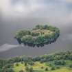
Photographs and Off-line Digital Images |
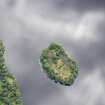
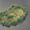
E 81224 PO |
Records of Aberdeenshire Archaeology Service, Aberdeen, Scotland |
Castle Island, Loch Kinord, oblique aerial view. |
27/1/1998 |
Item Level |
|
 |
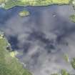
On-line Digital Images |
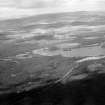
SC 1011789 |
Records of Aberdeen Aerial Surveys, Aberdeen, Scotland |
General oblique aerial view of Loch Kinord with Loch Davan beyond, looking to the NNE. |
22/8/1978 |
Item Level |
|
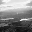 |
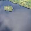
On-line Digital Images |
SC 1011791 |
Records of Aberdeen Aerial Surveys, Aberdeen, Scotland |
General oblique aerial view of Loch Kinord and Loch Davan beyond, looking to the SW. |
22/8/1978 |
Item Level |
|
|
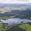
Print Room |
PA 29/18/1 |
General Collection. Photograph Albums. |
General view of Loch Kinnord |
|
Item Level |
|
 |
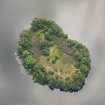
On-line Digital Images |
DP 313605 |
Historic Environment Scotland |
Oblique aerial view. |
20/8/2019 |
Item Level |
|
 |
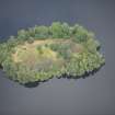
On-line Digital Images |
DP 313606 |
Historic Environment Scotland |
Oblique aerial view. |
20/8/2019 |
Item Level |
|
 |
On-line Digital Images |
DP 313607 |
Historic Environment Scotland |
Oblique aerial view. |
20/8/2019 |
Item Level |
|
 |
On-line Digital Images |
DP 313609 |
Historic Environment Scotland |
Oblique aerial view. |
20/8/2019 |
Item Level |
|
 |
On-line Digital Images |
DP 313610 |
Historic Environment Scotland |
Oblique aerial view. |
20/8/2019 |
Item Level |
|
 |
On-line Digital Images |
DP 313611 |
Historic Environment Scotland |
Oblique aerial view. |
20/8/2019 |
Item Level |
|
 |
On-line Digital Images |
DP 313613 |
Historic Environment Scotland |
Oblique aerial view. |
20/8/2019 |
Item Level |
|
 |
On-line Digital Images |
DP 313614 |
Historic Environment Scotland |
Oblique aerial view. |
20/8/2019 |
Item Level |
|
 |
On-line Digital Images |
DP 313615 |
Historic Environment Scotland |
Oblique aerial view. |
20/8/2019 |
Item Level |
|
|
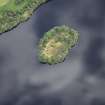
Photographs and Off-line Digital Images |
SC 1937444 |
Records of Aberdeenshire Archaeology Service, Aberdeen, Scotland |
Castle Island, Loch Kinord, oblique aerial view. |
27/1/1998 |
Item Level |
|
 |
On-line Digital Images |
SC 2407354 |
Records of the Ordnance Survey, Southampton, Hampshire, England |
Castle Island, Loch Kinord, NO49NW 16, Ordnance Survey index card, Recto |
c. 1958 |
Item Level |
|
 |
On-line Digital Images |
SC 2407355 |
Records of the Ordnance Survey, Southampton, Hampshire, England |
Castle Island, Loch Kinord, NO49NW 16, Ordnance Survey index card, page number 1, Recto |
c. 1958 |
Item Level |
|
 |
On-line Digital Images |
SC 2407356 |
Records of the Ordnance Survey, Southampton, Hampshire, England |
Castle Island, Loch Kinord, NO49NW 16, Ordnance Survey index card, page number 2, Verso |
c. 1958 |
Item Level |
|
 |
On-line Digital Images |
SC 2407357 |
Records of the Ordnance Survey, Southampton, Hampshire, England |
Castle Island, Loch Kinord, NO49NW 16, Ordnance Survey index card, page number 3, Recto |
c. 1958 |
Item Level |
|
|
All Other |
551 166/1/1 |
Records of the Ordnance Survey, Southampton, Hampshire, England |
Archaeological site card index ('495' cards) |
1947 |
Sub-Group Level |
|


