Pricing Change
New pricing for orders of material from this site will come into place shortly. Charges for supply of digital images, digitisation on demand, prints and licensing will be altered.
Rob's Reed
Dun (Iron Age)
Site Name Rob's Reed
Classification Dun (Iron Age)
Alternative Name(s) Pitscandly Hill
Canmore ID 33776
Site Number NO45SE 30
NGR NO 49067 52434
Datum OSGB36 - NGR
Permalink http://canmore.org.uk/site/33776
- Council Angus
- Parish Rescobie
- Former Region Tayside
- Former District Angus
- Former County Angus
NO45SE 30 4906 5243.
(NO 4906 5243) Robs Reed (NAT) Dun (NR)
OS 1:10,000 map, (1975)
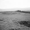
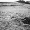
Rob's Reed is a dun, a single-walled enclosure, 32.0m in diameter overall and 16.0m internal diameter. The wall is now represented by a heap of small stones, overgrown with grass and spread to 7.7m. The interior lies 1.2m below the crest of the wall, and externally the wall is 1.0m high on the N, but elsewhere only c. 0.3m high. There is no positive trace of an entrance, but this may have been on the S where a footpath passes through the wall. Some slab-like stones lie around the site. The dun is situated on the W edge of a high E-W ridge with an extensive view. Traces of a square enclosure abut on the NW side of the dun. It comprises a low turf bank c. 3.0m broad and 0.1m high, enclosing an area 13.0m square. It would appear to be a fairly recent stock enclosure.
D Christison 1900; Visited by OS (JLD) 26 August 1958.
Field Visit (August 1942)
Rob's Reed.
Just below the crest of Pitscundy Hill, the W end of the ridge which culminates in Turin Hill, is a circular enclosure delimited by a grass-grown bank about 65' across internally. Though no facing stones are exposed this is probably the site of a ring fort similar to that on the summit of Turin Hill.
Visited by RCAHMS (VGC) August 1943.
Field Visit (9 August 1956)
This site was included within the RCAHMS Marginal Land Survey (1950-1962), an unpublished rescue project. Site descriptions, organised by county, are available to view online - see the searchable PDF in 'Digital Items'. These vary from short notes, to lengthy and full descriptions. Contemporary plane-table surveys and inked drawings, where available, can be viewed online in most cases - see 'Digital Images'. The original typecripts, notebooks and drawings can also be viewed in the RCAHMS search room.
Information from RCAHMS (GFG) 19 July 2013.
Field Visit (March 1978)
Rob's Reed NO 490 524 NO45SE 30
On the SW shoulder of Pitscandly Hill, there is a dun measuring 32m in diameter over a wall now reduced to a spread of rubble measuring 7.7m in thickness.
RCAHMS 1978, visited March 1978
(Christison 1900, 107; Coutts 1970, 37, no. 25)
Earth Resistance Survey (2 October 2017)
NO 49067 52434 (NO45SE 30) A c0.4ha area at the small ringfort of Rob’s Reed Fort was surveyed, 2 October 2017, using a Geoscan RM85 electrical resistance meter. The survey aimed to clarify the extent and nature of the fort and to identify any possible archaeological features within the interior or immediate environs of the site.
The survey clarified that the fort consists of a c2.4m wide stone wall with a probable entrance at the S side of the enclosure, consisting of a simple break measuring just over 2m. A possible 8m diameter structure abutting the eastern side of the inner face of the enclosure is faintly visible in the data.
Archive: University of Aberdeen
Funder: University of Aberdeen
James O’Driscoll – University of Aberdeen
(Source: DES, Volume 18)
Excavation
NO 4906 5243 Located on the western ridge upon which Turin Hill sits, another small enclosure known as ‘Rob’s Reed’(Canmore ID: 33776) is positioned strategically overlooking a broad tract of land to the W and SW. The fort measures approximately 32m in diameter with an internal diameter of 16m.Sample excavation targeted the inner face of this enclosure, in order to obtain radiocarbon samples from occupation surfaces and pre-bank layers to date the enclosure. A portion of a large hearth abutting the wall was identified. The trench was not bottomed in order to preserve the heath in-situ. Samples for dating were retrieved from the hearth and from occupation layers above.
Archive: University of Aberdeen
Funder: Leverhulme Trust
James O’Driscoll and Gordon Noble - University of Aberdeen
(Source: DES Vol 20)
OASIS ID: jamesodr1-407620


