
Arniefoul


Cairn (Early Prehistoric)
Site Name Arniefoul
Classification Cairn (Early Prehistoric)
Alternative Name(s) Haystone Hill; Airneyfoul; Round Cairn, Arniefoul
Canmore ID 33651
Site Number NO44SW 1
NGR NO 4076 4491
Datum OSGB36 - NGR
Permalink http://canmore.org.uk/site/33651


- Council Angus
- Parish Glamis
- Former Region Tayside
- Former District Angus
- Former County Angus
NO44SW 1 4076 4491.
(NO 4076 4491) Fort (NR)
OS 6" map, (1959)
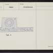
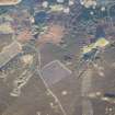
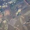
A flat-topped round cairn, 67-70' in diameter at base, and 5-6' high, covered with heather and blaeberries. A number of large stones protrude from its flanks, and several pits have been dug into it round the top, but apparently not deep enough to disturb a primary burial. The cairn is surrounded eccentrically by an earth and stone bank, 9-10' thick, with a gap, 9' wide, in the cetnre of its E side, but it is not possible to say if it is original or secondary. The fact the bank is eccentric to the cairn, coupled with its stony nature, seems to rule out its interpretation as a bell-cairn, the bank probably being a modern addition similar to the feal-dyke at Cairnpapple or Andrew's Knowe, Roxburghshire. It may even have been erected to isolate and protect the cairn when the open caste shale-pits roundabout were being worked.
NSA (1845) suggest it may be a Roman signal-station; Christison (1900) considers it may be a motte.
NSA 1845; D Christison 1900; Information from RCAHMS TS 8 August 1956.
(Previously scheduled as Round Cairn, Arniefoul). Scheduled as Arniefoul, cairn.
Information from Historic Scotland, scheduling document dated 12 December 2001.
Field Visit (8 August 1956)
This site was included within the RCAHMS Marginal Land Survey (1950-1962), an unpublished rescue project. Site descriptions, organised by county, are available to view online - see the searchable PDF in 'Digital Items'. These vary from short notes, to lengthy and full descriptions. Contemporary plane-table surveys and inked drawings, where available, can be viewed online in most cases - see 'Digital Images'. The original typecripts, notebooks and drawings can also be viewed in the RCAHMS search room.
Information from RCAHMS (GFG) 19 July 2013.
Note (1983)
Haystone Hill, Arniefoul NO 407 449 NO44SW 1
Situated on the W shoulder of Haystone Hill 800m NE of Arniefoul farmhouse, there is a cairn 21 m in diameter and 1.8m high. A bank surrounding the cairn is probably of recent date.
RCAHMS 1983
(Christison 1900, 54, no. 5; Coutts 1970, 8, no. 1).

