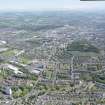
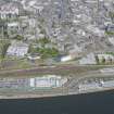
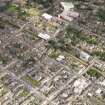
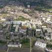
Accessibility

Font Size

100% 150% 200%

Background Colour

Default Contrast
Close Reset

Dundee, General

Burgh (Medieval), General View (Period Unassigned), Town (Period Unassigned)

Site Name Dundee, General

Classification Burgh (Medieval), General View (Period Unassigned), Town (Period Unassigned)

Canmore ID 33538

Site Number NO43SW 76

NGR NO 40 30

Datum OSGB36 - NGR

Permalink http://canmore.org.uk/site/33538

Ordnance Survey licence number AC0000807262. All rights reserved.
Canmore Disclaimer. © Bluesky International Limited 2025. Public Sector Viewing Terms

Toggle Aerial | View on large map

Digital Images

General oblique aerial view centred on the city, taken from the SW (N Fife coast).
General oblique aerial view centred on the city, taken from the SW (N Fife coast).General oblique aerial view of the Balgay and Lochee areas of the city centred on the city centre, taken from the ESE.Oblique aerial view.View looking ESE from staff club showing Tay Road Bridge in distance with part of Dundee in foreground including railway stationGeneral oblique aerial view centred on the city, taken from the SW.General oblique aerial view centred on the city, taken from the SE.General oblique view centred on the city, taken from the SW.General oblique aerial view of the Balgay and Lochee areas of the city centred on the city centre, taken from the ESE.View of building exterior.
Titled: ' Powrie Lane 1873'.

General oblique aerial view of the River Tay centred on the Tay Bridge, taken from the SW.Oblique aerial view of Tay Bridge, taken from the SSE.Oblique aerial view.Oblique aerial view.Oblique aerial view.General oblique aerial view lookings along the Firth of Tay with the bridges and Dundee in the distance, taken from the NE.General oblique aerial view lookings along the Firth of Tay towards the bridges and Dundee, taken from the NE.General oblique aerial view of Caledon East Wharf at Stannergate, Dundee, taken from the SSE.Oblique aerial view.General oblique aerial view.Oblique aerial view.General oblique aerial view centred on the city, taken from the SE.General oblique aerial view centred on the city, taken from the ENE.General oblique aerial view of the River Tay centred on the Tay Bridge with Dundee beyond, taken from the SW.Oblique aerial view.General oblique aerial view.Oblique aerial view.Oblique aerial view.Oblique aerial view along the north shore of the Firth of Tay over Dundee, looking W.View looking ESE from staff club showing Tay Road Bridge in distance with part of Dundee in foregroundGeneral view looking NNW showing DundeeGeneral oblique aerial view centred on the city, taken from the SSW.General oblique aerial view of the River Tay centred on the Tay Bridge, taken from the S.Oblique aerial view of Tay Bridge with Dundee beyond, taken from the SSE.Oblique aerial view.Oblique aerial view.Oblique aerial view.Oblique aerial view.General oblique aerial view centred on the city, taken from the SE.General oblique aerial view of oil platform construction at Stannergate, Dundee, taken from the SSE.General oblique aerial view of Dundee, centred on Grove Academy, taken from the SSE.General oblique aerial view of the River Tay centred on the Tay Bridge, taken from the SW.Dundee, General, NO43SW 76, Ordnance Survey index card, RectoGeneral oblique aerial view centred on the city, taken from the W.General oblique aerial view lookings along the Firth of Tay with the bridges and Dundee in the distance, taken from the NE.General oblique aerial view of University of Dundee campus, taken from the SE.General oblique aerial view.Dundee, General, NO43SW 76, Ordnance Survey index card, RectoView of Dundee. 
General oblique aerial view centred on the city, taken from the SSW.General oblique aerial view centred on the city, taken from the ENE.General oblique aerial view of the Balgay and Lochee areas of the city centred on the city centre, taken from the ESE.Pl.38 Dundee. Copy of copper plate engrqving titled 'Prospectus Civitatis Taoduni. The Prospect of ye Town of Dundee. This plate is most humbly inscribed toThomas Paterson Esq.'Distant view of Dundee from North Hill.General oblique aerial view of Dundee, centred on the harbour and Discovery Point, taken from the SE.General oblique aerial view of the River Tay centred on the Tay Bridge, taken from the SE.General oblique aerial view.Oblique aerial view.Oblique aerial view.

Administrative Areas

  • Council Dundee, City Of
  • Parish Dundee (Dundee, City Of)
  • Former Region Tayside
  • Former District City Of Dundee
  • Former County Angus

Archaeology Notes

NO43SW 76 40 30.

King William gave to his brother, earl David, the villa of Dundee in 1178 x 1182 and by 1195 it was a burgh of the earl. On the death of earl John in 1237 or more probably on that of the lady Devorguilla in 1290 it reverted to the crown.

G S Pryde 1965.

References

MyCanmore Image Contributions


Contribute an Image

MyCanmore Text Contributions