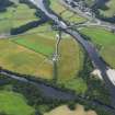
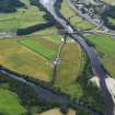
Accessibility

Font Size

100% 150% 200%

Background Colour

Default Contrast
Close Reset

Pricing Change

New pricing for orders of material from this site will come into place shortly. Charges for supply of digital images, digitisation on demand, prints and licensing will be altered. 


Logierait Mill

Rig And Furrow (Medieval) - (Post Medieval)

Site Name Logierait Mill

Classification Rig And Furrow (Medieval) - (Post Medieval)

Canmore ID 334101

Site Number NN95SE 102

NGR NN 9756 5150

Datum OSGB36 - NGR

Permalink http://canmore.org.uk/site/334101

Ordnance Survey licence number AC0000807262. All rights reserved.
Canmore Disclaimer. © Bluesky International Limited 2025. Public Sector Viewing Terms

Toggle Aerial | View on large map

Digital Images

Collections

Administrative Areas

  • Council Perth And Kinross
  • Parish Logierait
  • Former Region Tayside
  • Former District Perth And Kinross
  • Former County Perthshire

Activities

Aerial Photography (23 July 2010)

A small patch of rig and furrow has been recorded as cropmarking on an oblique aerial photograph (RCAHMSAP 2010) immediately to the SE of Logierait Mill.

Information from RCAHMS (DCC) 9 January 2014

References

MyCanmore Image Contributions


Contribute an Image

MyCanmore Text Contributions