
Following the launch of trove.scot in February 2025 we are now planning the retiral of some of our webservices. Canmore will be switched off on 24th June 2025. Information about the closure can be found on the HES website: Retiral of HES web services | Historic Environment Scotland
St Bride's Ring


Settlement (Iron Age)
Site Name St Bride's Ring
Classification Settlement (Iron Age)
Alternative Name(s) Kingennie House
Canmore ID 33339
Site Number NO43NE 4
NGR NO 4746 3536
Datum OSGB36 - NGR
Permalink http://canmore.org.uk/site/33339


- Council Angus
- Parish Monifieth (Angus)
- Former Region Tayside
- Former District City Of Dundee
- Former County Angus
NO43NE 4 4746 3536.
(NO 4746 3536) St Bride's Ring (NAT) Fort (NR)
OS 6" map, (1971)
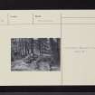
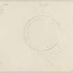
St Bride's Ring measures c. 60' in diameter with walls c. 7' thick and 1'6" high. Jervise (1859) states that the entrance is on the S, but Neish (1862) says that it is on the E. Many large blocks (fallen from the walls) lie in the dell below.
A Jervise 1859; J Neish 1862.
Though St Bride's ring has been classified as a broch by some authorities, it lacks the structural details, eg. guard cell, intra-mural staircase, of this type of monument. It is comparable with the ring forts of central Perthshire (now, ie. 1975, recognised as homesteads - c/f NN44SE 7).
V G Childe 1939.
St Bride's Ring is situated on a projecting spur with steep slopes all round except on the SE where there is a level approach. The wall, composed of large boulders, is 2.0m - 2.5m thick and 0.3m - 1.0m high. It is best preserved on the S and E sides. The internal diameter is 15.0m. Only one break was noted - on the E. It is 2.0m wide and is flanked by two large, flat-sided boulders on the S side. The site is covered by trees.
Visited by OS (J L D) 15 May 1958.
Field Visit (22 April 1957)
This site was included within the RCAHMS Marginal Land Survey (1950-1962), an unpublished rescue project. Site descriptions, organised by county, are available to view online - see the searchable PDF in 'Digital Items'. These vary from short notes, to lengthy and full descriptions. Contemporary plane-table surveys and inked drawings, where available, can be viewed online in most cases - see 'Digital Images'. The original typecripts, notebooks and drawings can also be viewed in the RCAHMS search room.
Information from RCAHMS (GFG) 19 July 2013.

