
Pricing Change
New pricing for orders of material from this site will come into place shortly. Charges for supply of digital images, digitisation on demand, prints and licensing will be altered.
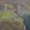
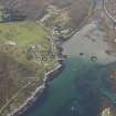
Coll, Arinagour


Kelp Grid (Post Medieval)
Site Name Coll, Arinagour
Classification Kelp Grid (Post Medieval)
Canmore ID 332276
Site Number NM25NW 88
NGR NM 22591 57515
Datum OSGB36 - NGR
Permalink http://canmore.org.uk/site/332276


- Council Argyll And Bute
- Parish Coll
- Former Region Strathclyde
- Former District Argyll And Bute
- Former County Argyll
Aerial Photography (31 August 2010)
A roughly rectangular spread of seaweed covered stones in the bay at Arinagour may be the remains of a small kelp grid.
Information from RCAHMS (DCC) 3 September 2013

