
Inverness, Dalcross Airfield, Battle H.q.


Battlefield Headquarters (20th Century)
Site Name Inverness, Dalcross Airfield, Battle H.q.
Classification Battlefield Headquarters (20th Century)
Canmore ID 332172
Site Number NH75SE 31.07
NGR NH 76715 51207
Datum OSGB36 - NGR
Permalink http://canmore.org.uk/site/332172


- Council Highland
- Parish Petty
- Former Region Highland
- Former District Inverness
- Former County Inverness-shire
External Reference (June 2012)
The approximate location of a battle HQ (Type 1008/41) has been recorded at Dalcross Airfield.
Information from the UK Pillbox Studies Group, June 2012
External Reference (20 July 2013)
Located on high ground over looking inverness airport. The bunker is in good condition it is dry and free from rubbish. The emergency hatch is missing but can be found inside. The emergency ladder is still in place. The bunker features many orignal features, light fitting, light switches and wooden doors complete with their RAF green paint.
Information from M Tucknott, 20th July 2013
Standing Building Recording (28 July 2022)
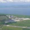
NH 76965 51242 A historic building survey was carried out of two Second World War bunker-type structures at the former RAF Dalcross, now Inverness Airport. The assessment comprised a descriptive record and photographic survey of the structures in advance of construction works associated with the Inverness Airport Station.
The first structure was identified as a reinforced concrete and brick lined observation post relating to the Second World War airfield. A more specific purpose is unclear due to the lack of identifying features surviving in the structure. The second structure could not be accessed but was likely used for bulk storage. Additional investigation would be required for more detailed conclusions to be drawn. Neither of the structures are likely to be disturbed by proposed site works.
Information from A Milne – Headland Archaeology (UK) Ltd
(Source: DES Volume 23)
OASIS ID: headland1-508631
Change Of Location (13 October 2022)
The Battle HQ is visible on a 25cm georeferenced aerial photograph at NH 76715 51207. Previously record at NH 7672 5152.
Information from HES 13 October 2022

