
Pitmackie


Farmstead (Period Unassigned)(Possible)
Site Name Pitmackie
Classification Farmstead (Period Unassigned)(Possible)
Canmore ID 331437
Site Number NN84SW 49
NGR NN 81615 40334
Datum OSGB36 - NGR
Permalink http://canmore.org.uk/site/331437


- Council Perth And Kinross
- Parish Dull
- Former Region Tayside
- Former District Perth And Kinross
- Former County Perthshire
External Reference (7 June 2013)
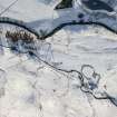
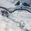
A short distance from the north bank of the River Quoich and centred on NN 81615 40334 are the scant remains of two, or perhaps three, buildings, none of which is represented on the first edition OS 6-inch map.
Building 1 measures 8m east/west by 4m wide externally, the walls being overlain by vegetation. It is divided internally by a cross wall; otherwise no other features are discernible. To its immediate east is Building 2 which measures 6m east/west by 4.5m wide externally. It appears to be sub-rectangular in shape although wall tumble makes it difficult to accurately assess its outline.
The possible remains of a third building, 8m long, lie to the immediate east of Building 2 although its entire outline is difficult to trace.
Information from J Lewis, Scotia Archaeology 7 June 2013
Field Visit (24 May 2013)
NN 8056 4008 – NN 8190 4033, NN 8122 4100 – NN 8149 4049 Walkover surveys were undertaken on 24 May 2013 along the proposed routes of two hydro-electric schemes at Pitmackie, Glen Quaich. A desk-based assessment had identified the remains of several farmsteads (NN84SW 11, NN84SW 12, NN84SW 13, NN84SW 14, NN84SW 23, NN84SW 24) along these routes. However, two further settlements were encountered during the walkover survey. The scant remains of a probable farmstead consisting of two, or possibly three, buildings was identified on the N bank of the River Quaich at NN 81615 40334. Close to an unnamed burn that feeds into the river, at NN 81229 40864, stand the surviving courses of what was probably a shieling hut.
Archive and report: PKHT and RCAHMS
Funder: Green Highland Renewables
John Lewis, Scotia Archaeology, 2013
(Source: DES)
Field Visit (26 May 2014)
Alder Archaeology Ltd was commissioned by Highland Eco-Design Ltd, to inform works required for the protection of archaeological sites and the reinstatement of field boundaries on the site of the proposed Hydro Scheme, Pitmackie Burn, Amulree.
On 26 May 2014 a site visit was made by Alder Archaeology and Dan Long from Highland Eco-Design to inspect affected sites and to agree the methodology for fencing off and the reinstatement for breaches in the field boundaries. During the visit canes were placed about sites to mark out the location for the required protective fencing. Now that locations for protective fencing and requirements for reinstatement of field boundaries have been agreed there is no further requirement for archaeological visits.
Information from Alder Archaeology Ltd.

