
Pricing Change
New pricing for orders of material from this site will come into place shortly. Charges for supply of digital images, digitisation on demand, prints and licensing will be altered.
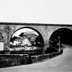
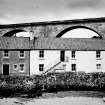
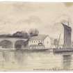
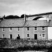
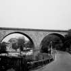
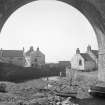
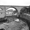
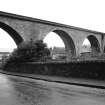
Lower Largo, Station Wynd, Old Railway Viaduct


Railway Viaduct (19th Century)
Site Name Lower Largo, Station Wynd, Old Railway Viaduct
Classification Railway Viaduct (19th Century)
Alternative Name(s) Keil Burn
Canmore ID 32850
Site Number NO40SW 79
NGR NO 41689 02636
Datum OSGB36 - NGR
Permalink http://canmore.org.uk/site/32850


- Council Fife
- Parish Largo
- Former Region Fife
- Former District North East Fife
- Former County Fife
Publication Account (2013)
LOWER LARGO VIADUCT
Largo viaduct, 1857 four masonry arches on the NBR route to St Andrews, closed in 1964. It makes a strong impression in the small town.
M Watson, 2013
Note
1857 viaduct closed to all rail traffic in 1966.
Information received from B Malaws (RCAHMW), 5 December 2013; noted by RCAHMS (MMD), 5 December 2013.

