
Following the launch of trove.scot in February 2025 we are now planning the retiral of some of our webservices. Canmore will be switched off on 24th June 2025. Information about the closure can be found on the HES website: Retiral of HES web services | Historic Environment Scotland
Glen Fruin, St. Bride's Chapel


Cross Slab (Early Medieval)
Site Name Glen Fruin, St. Bride's Chapel
Classification Cross Slab (Early Medieval)
Alternative Name(s) Kilbride School House
Canmore ID 319279
Site Number NS38NW 1.01
NGR NS 3069 8661
Datum OSGB36 - NGR
Permalink http://canmore.org.uk/site/319279


- Council Argyll And Bute
- Parish Rhu
- Former Region Strathclyde
- Former District Dumbarton
- Former County Dunbartonshire
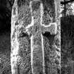
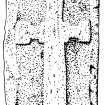
Glen Fruin, Dunbartonshire, cross-slab
Measurements: H 0.9m above ground, W 0.48m, D 0.23m
Stone type: sandstone
Place of discovery: NS 3069 8661
Present location: set upright near the north-east side of the garden.
Evidence for discovery: found buried in the grounds of Kilbride Schoolhouse prior to 1924 and set upright.
Present condition: very worn and there is extensive edge-damage.
Description
The slab is bordered by a wide flat-band moulding, and the panel enclosed is almost filled by a cross in low relief. There is a square at the centre and the side-arms have rectangular terminals, whereas the upper arm is plain and elongated. An unusual feature at the base of the shaft, which is a horizontal bar, presumably indicating a base-stone.
Date range: early medieval.
Primary references: Lacaille 1924, 128-30; Fisher 2001, 84, no 12.
Desk-based information compiled by A Ritchie 2019
Field Visit (18 January 1963)
No remains of the chapel are to be found. The cross-slab, as described by Lacaille, stands at NS 3069 8661.
Visited by OS (EGC) 18 January 1963
Reference (2001)
The former schoolhouse on the NE bank of the Fruin Water, 2.2km SE of Ballevoulin (No.13), is believed to stand on or close to the site of St Bride's Chapel (1). The property was known in the 17th century as Chapel of Glen Fruin, and lies between the farms of East and West Kilbride. Stones from the chapel are said to have been built into the schoolhouse (2), and a cross-marked slab found buried in the grounds early in the 20th century stands at the NE edge of the garden close to the road.
The slab is of sandstone and measures 0.9m in visible height by 0.48m and 0.23m thick. It is carved in false relief within a flat margin varying in width from 50mm to 80mm, and bears a Latin cross with a square central expansion and transverse bars at the ends of the transom. The top arm and shaft taper slightly towards the centre, and there is an additional bar, perhaps representing a cross-base, at the foot.
Footnotes:
(1) H Campbell 1933, no.478; Name Book, Dunbartonshire, No.17, pp.53-4; Battrum's Guide to Helensburgh and Neighbourhood 1865, 67; Sir W Fraser 1869, 2, 116-17; J Irving 1879, 2, 290, 302. This was proposed in the 17th century as the site for a chapel of ease, and it remained in ecclesiastical ownership in the 19th century (Irving, op.cit., 302).
(2) Battrum, loc. cit. For a medieval stoup which may have come from this site, see Lacaille 1935, 418-19.
Lacaille 1924, 128-30; RCAHMS 1978d, no.70.
I Fisher 2001, 84.

