
Following the launch of trove.scot in February 2025 we are now planning the retiral of some of our webservices. Canmore will be switched off on 24th June 2025. Information about the closure can be found on the HES website: Retiral of HES web services | Historic Environment Scotland
Auchterhouse


Cairn (Prehistoric)(Possible), Fort (Prehistoric)
Site Name Auchterhouse
Classification Cairn (Prehistoric)(Possible), Fort (Prehistoric)
Alternative Name(s) Auchterhouse Hill
Canmore ID 31874
Site Number NO33NE 3
NGR NO 3543 3975
Datum OSGB36 - NGR
Permalink http://canmore.org.uk/site/31874


- Council Angus
- Parish Auchterhouse
- Former Region Tayside
- Former District City Of Dundee
- Former County Angus
NO33NE 3 3543 3975.
(NO 3543 3975) Fort (NR)
OS 6" map, (1971)
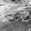
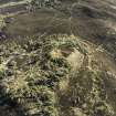
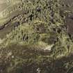
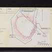
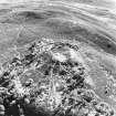
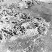
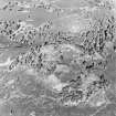
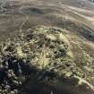
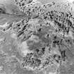
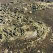
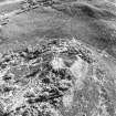
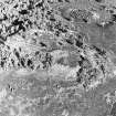
A fort occupying a plateau slightly below the crest of Auchterhouse Hill.
The plateau is precipitous on the south and west and is defended on the east and SE by a set of five ramparts with medial ditches, the ramparts reaching a maximum height of 1.5m above the base of the ditch. There are possible traces of a single stone wall running round the north and NW.
Internally the fort is covered with trees, the southern half being occupied by a high natural knoll.
At NO 3545 3984 on the edge of the steep north slope is a possible cairn 5.0m in diameter consisting of a continuous circle, of large stones embedded in the ground. The interior is filled with stone to a height of 0.2m.
Surveyed at 1:2500.
Statistical Account (OSA) 1794; Visited by OS (E G C) 14 December 1967.
Field Visit (28 August 1958)
This site was included within the RCAHMS Marginal Land Survey (1950-1962), an unpublished rescue project. Site descriptions, organised by county, are available to view online - see the searchable PDF in 'Digital Items'. These vary from short notes, to lengthy and full descriptions. Contemporary plane-table surveys and inked drawings, where available, can be viewed online in most cases - see 'Digital Images'. The original typecripts, notebooks and drawings can also be viewed in the RCAHMS search room.
Information from RCAHMS (GFG) 19 July 2013.
Note (13 May 2015 - 24 May 2016)
A large fort is situated on the broad plateau surrounding summit knoll of Auchterhouse Hill. It is defended by up to five ramparts with intermediate ditches on the SE and E, the two outer apparently earthen and standing up to 1.5m above the bottom of the intervening ditch, but the three inner heavily reduced by stone-robbing and barely visible. Indeed in 1967, the OS could trace only a single rampart round the NE and NW, while the steep SW flank was apparently left undefended. No detailed measurements of the interior have been recorded, but it measures in the order of 160m from N to S by 135m transversely (1.73ha), and no entrances have been observed. The only feature in the interior is what may be an earlier cairn measuring about 5.8m in diameter by 0.2m in height over a kerb of boulders.
Information from An Atlas of Hillforts of Great Britain and Ireland – 24 May 2016. Atlas of Hillforts SC3066

