
Pricing Change
New pricing for orders of material from this site will come into place shortly. Charges for supply of digital images, digitisation on demand, prints and licensing will be altered.
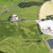
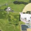
Priestdykes


Barrow (Prehistoric), Field Boundary (Period Unassigned)
Site Name Priestdykes
Classification Barrow (Prehistoric), Field Boundary (Period Unassigned)
Canmore ID 318599
Site Number NY18SW 231
NGR NY 1030 8137
Datum OSGB36 - NGR
Permalink http://canmore.org.uk/site/318599


- Council Dumfries And Galloway
- Parish Lochmaben
- Former Region Dumfries And Galloway
- Former District Annandale And Eskdale
- Former County Dumfries-shire

