
Howes Smallholdings


Barrow(S) (Prehistoric)(Possible)
Site Name Howes Smallholdings
Classification Barrow(S) (Prehistoric)(Possible)
Canmore ID 318598
Site Number NY16NE 266
NGR NY 17588 66739
Datum OSGB36 - NGR
Permalink http://canmore.org.uk/site/318598


- Council Dumfries And Galloway
- Parish Annan
- Former Region Dumfries And Galloway
- Former District Annandale And Eskdale
- Former County Dumfries-shire
Aerial Photographic Transcription (28 September 2012)
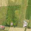
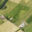
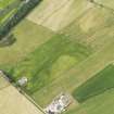
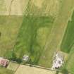
These eight possible round barrows and a scatter of pits have been recorded as cropmarks on oblique aerial photographs (RCAHMSAP 2012). The barrows are roughly circular on plan and measure between 5m and 7.5m in diameter within a ditch about 1.5m across, broken by a clear causeway in two cases. There are possible grave pits in the interior of four of the barrows and a scatter five possible unenclosed grave pits, visible as small ‘maggot-like’ cropmarks.
Information from RCAHMS (KHJM) 28 Sept 2012

