Eday, Vinquoy Hill
Chambered Cairn (Neolithic)
Site Name Eday, Vinquoy Hill
Classification Chambered Cairn (Neolithic)
Canmore ID 3183
Site Number HY53NE 9
NGR HY 5601 3812
Datum OSGB36 - NGR
Permalink http://canmore.org.uk/site/3183
- Council Orkney Islands
- Parish Eday
- Former Region Orkney Islands Area
- Former District Orkney
- Former County Orkney
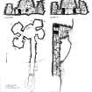
The Neolithic chambered cairn on Vinquoy Hill commands views across much of the Orkney archipelago. It measures approximately 17m in diameter and 2.5m in height and has an entrance passage leading to a central chamber with four small side-cells.
Information from RCAHMS (SC) 14 August 2007
Ritchie, A and Ritchie, G 1998
HY53NE 9 5601 3812.
(HY 5601 3812 ) Erd House (NR)
OS 6"map, Orkney, 2nd ed.,(1900).
A Maes-Howe-Type chambered cairn, now overgrown with heather, was excavated by Farrer and Hebden, in 1857 (G Petrie 1863) who are presumably responsible for the shallow depression in the top of the cairn to gain access to the chamber through the roof.
The cairn, much disturbed at the edges, appears to have been about 58' in diameter. Built on a gentle slope the height on the north side appears to be 4' while on the south it is about 8'. It does not seem to have been much higher and probably only just covered the lintels,for it rises only 2' above the present wall-head of the chamber.
There has been at least one encircling wall-face within the cairn a small portion of which is exposed flush with the outer edge of the outermost lintel of the passage One stone exists above the lintel and the wall-face can be traced to the west for 4' and rises to a height of 3' above the level of the passage roof.
A S Henshall, visited 1957; RCAHMS 1946.
A chambered cairn, as described and planned by Henshall.
Re-surveyed at 1/2500.
Visited by OS (NKB) 24 July 1970.
'The Orcadian' describes the excavation of this site in 1857.
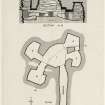
The chambered cairn is situated on the S end of the summit of the heather-covered ridge forming Vinquoy Hill, with the actual summit being a little to the N; the site offers magnificent views in all directions to North Ronaldsay, Sanday, Shapinsay, Westray, Rousay and indeed Fair Isle. The cairn is grass-and heather-covered, and is difficult to distinguish from the surrounding ground, but it appears to be about 17.7 m in diameter and 2.5 m in height. The cairn covers a tomb of Maes-Howe type with an entrance-passage leading to a central chamber with four small side-cells entered from the NW, SW, NE and SE sides of the chamber.
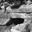
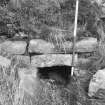
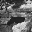
The entrance-passage is on the S; the line of part of the cairn revetment is visible above the lintel across the passage, but the extent of the cairn material beyond this is uncertain, both because of what appears to be Iron Age activity, and also because of debris thrown out during the excavations in 1857. There are large quarry scoops to the S and W of the mound, and it is possible that the plateau that has been formed on the SW side is the result of quarrying for building-material for the tomb. There is perhaps an expected difference between the outline of the cairn on the N and W parts, where it has been quarried back into the hillslope, and on the S and E where it has been built up to a greater extent. The entrance-passage has been carefully constructed with large blocks; in the outer part of the E side much of the face is made up with a single large block, with two courses of drystone walling above to an overall height of 0.72m. The block, which may be largely natural, certainly rests on the underlying rock, and the floor of the passage has been dug to a level surface. The W wall also incorporates several large blocks including one near the entrance lintel, but, as on the E, a large slab just beneath the lintel shows that the passage is all of one period of building. On the E wall-face, a large slab within the passage below the lintel overlies another large slab that overlies the large block already mentioned. There is no sign of any further roofing slabs, and it is likely that the tomb was entered through an open outer passage before the roofed portion began. The passage is composed of a basal layer of large boulders with long slabs and drystone walling above to form the seating for the roofing slabs. There are two large roofing-slabs at the front, two on edge and then three large slabs at the back. The passage measures some 5m in length, 0.55m in breadth and 0.92m in height. The widening of the passage, up to 0.7m at the W end, is due largely to its construction on an area of level bedrock, and the stones of the walls have been set back a little to take account of this. The inner end of the passage is built of particularly massive boulders, and at the point where it enters the main chamber, the passage measures about 0.5m broad and 0.98m in height.
The passage enters onto the central chamber, which is polygonal in ground plan with straight segments largely dictated by long straight slabs, some of which form the lintels to the side-cells, which are themselves the lowest courses of the side walls. The walls rise vertically to lintel height, after which they oversail, sometimes in straight segments, to a surviving height of 2.9m. Above the SE cell at a height of 2.06m above floor level, a rounded beach stone (0.25m by 0.lm) projects about 0.25m from the wall. This appears to be an original feature (and might be interpreted as a ledge for a lamp or votive deposit). It is possible that the top of the pebble has been deliberately flattened. On the floor of the central chamber close to the W wall there is a pit; it has sloping sides and is about 0.4m in diameter and 0.12m deep.
The lintel of the inner end of the passage overlies that of the SE cell, and thus shares the pier of stonework at the S side of the entrance. Thus on the E side of the chamber the lintel of the SE cell was in position at an early stage of construction and the lintels of the NE cell and the passage were subsequently placed over it. On the W side, the lintels of the NW cell and the inner lintel of the SW cell are on the same level with the outer lintel of the SW cell overlying both. The main lintels of the side-cells are thus all on the same level as the lintel of the entrance-passage, although not all in direct association with it.
The SW cell is entered by a passage 1m long and 0.5m broad at the outer end and 0.75m broad at the inner end. At the outer end there is a sill stone, which runs under the stones that form the sides of the entrance. The slab is 0.14m thick and up to 0.lm high on the cell side. The sides of the entrance are formed by a massive block on the SE and a pier of masonry made up of two blocks on the NW. At a height of 0.8m the passage is roofed by a very massive slab that appears to run the complete length of the inner side of the cell and must be at least 1.5m long, 0.24m thick and 0.75m broad. The inner jamb-stones are also massive blocks with some eke-stones to help to support them. At present there gaps between the main uprights, but it is likely that these voids are the result of the collapse of the drystone walling that has formally filled the spaces. The interior of the chamber measures 1.5m by 1m; the wall rises vertically with bedrock coming through in the W angle to a height of about 1m and then starts to corbel slightly inwards. The cell is roofed by a single massive flat slab at a height of 1.5m.
The floor of the NW cell is cut partly into rock and is on occasion filled with water. The cell is entered by a short passage that uses the pier of masonry which it shares with its S neighbour on the one side and the wall of the main chamber on the other side. The lintel is at least 1.6m long, 0.23m thick and 0.65m broad. The walls of the cell are less regular than those of its neighbour, rising with a rough corbel from ground level virtually on all sides (though not that backing onto the main chamber), and it is roofed, not by a single flat slab, but by three blocks set on edge at a height of 1.9m.
The NE cell is entered immediately from the corner of the main chamber - there is no entrance-passage; the entrance is about 0.4m broad and 0.9m high. The lintel is a large slab and lies on top of the lintel to the SE cell; the lintel measures 1.12m in length, 0.62m in breadth, and 0.2m in thickness. The S wall of the cell, which it shares with the SE cell, is a pier of masonry with three large slabs, two of which fill the space between the main chamber and the back of the cell walls. A third slab, forming the wall of the chamber, supports the lintel of the SE cell, which in turn supports the lintel of the NE one. What is now a gap between these two stones and the rear wall of both cells is presumably the result of stones falling from the wall. The floor plan is irregular, the walls rising vertically till about the height of the lintel (about 1m above the floor), then oversailing little by little to a height of 1.8m, at which point the cell is roofed by a large flat slab. The bottom of the NE wall has been cut into the natural rock which also forms the floor on this side.
The SE cell is entered through a short passage, the principal elements of which, are the pier of masonry between the NE and SE cells and a pier between the main chamber and the W wall of the cell. Two blocks form the lowest course with a large block covering both the lintels and spanning the entrance; it measures 1.3m in length 0.62m in breadth and up to 0.2m in thickness. The cell walls are vertical to lintel-height and then they corbel inwards, with some very large blocks forming elements of the construction; the cell is finally covered by a flat slab at a height of 1.74m.
Visited by RCAHMS (JNGR) 1983.
This tomb, at 72m OD, commands a fine view from a S shoulder of Vinquoy Hill. In 1857 Farrer and Hebden dug down through the centre of the prominent covering mound and so broke into the irregularly-shaped chamber of Maes Howe type, with four side-compartments. They subsequently cleared the entrance-passage, but this is now almost choked up. This monument is in process of being gifted by Mrs Joy to Orkney Islands Council with a view to its repair and display to the public as a feature of the proposed 'Eday Tourist Interest Zone'.
D Fraser 1982; RCAHMS 1984, visited May 1983.
Measured Survey (1929)
Field Visit (24 July 1970)
A chambered cairn, as described and planned by Henshall.
Re-surveyed at 1/2500.
Measured Survey (1985)
RCAHMS surveyed the chambered cairn at Vinquoy in 1985 in response to a request from the Orkney Archaeologist (DES 1985, 69). The plan and sections were redrawn in ink and published at a reduced scale (Ritchie 1995, 148).
Publication Account (1996)
Set on a hilltop, this tomb commands a very extensive view over Orkney. It is a well-preserved and restored example of a Maes Howe type of tomb, with a main chamber and four side-cells. As it was built on a slope, the tomb is partly subterranean, with its entrance downs lope and a level floor created by digging back into the hillside. The main chamber must originally have been at least 3m high, and the corbelling of its roof cannot have been an easy task given the irregular fracturing of the local stone.
Nothing is known of the original contents of the tomb.
Information from ‘Exploring Scotland’s Heritage: Orkney’, (1996).
Field Visit (8 May 2013)
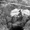
This grass- and heather-grown cairn is generally as previously described, except the entrance is now closed with an iron gate. Water worn cobbles partly fill the narrow gully that has been cut through the debris to reach this and these may possibly represent some of the original blocking material. Some spoil from the excavation appears to have been cast onto the SSE flank of the cairn.
The site is shown on the 1st and 2nd editions of the OS map (Orkney 1882 and 1903, Sheet LXXXVI), along with the legend ‘Erd House’, which refers to the first recorded interpretation of the monument.
Visited by RCAHMS (ATW) 8 May 2013.


