
Eday, Stone Of Setter


Stack Stand (19th Century) - (20th Century), Standing Stone (Prehistoric)
Site Name Eday, Stone Of Setter
Classification Stack Stand (19th Century) - (20th Century), Standing Stone (Prehistoric)
Canmore ID 3180
Site Number HY53NE 6
NGR HY 56456 37177
Datum OSGB36 - NGR
Permalink http://canmore.org.uk/site/3180


- Council Orkney Islands
- Parish Eday
- Former Region Orkney Islands Area
- Former District Orkney
- Former County Orkney
HY53NE 6 5645 3718.
(HY 5646 3717 ) Stone of Setter (NR)
OS 6" map, Orkney, 2nd ed., (1900).
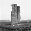
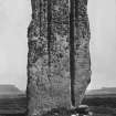
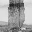
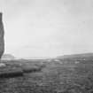
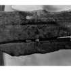
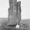
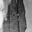
A large monolith, facing N-S, of irregular shape and much weathered on both faces. It is 15'6" high approx., 5'6" wide at base and 7' wide across the north side at 5' above ground. The thickness varies from 7 1/2" at base to 14" at the middle. The top is very irregular.
RCAHMS 1946.
'Stone of Setter'as described by the RCAHMS.
Visited by OS (NKB) 24 July 1970.
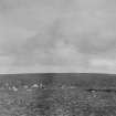
With a height of 4.5m this stone is, the Stenness circle apart, the tallest monolith in Orkney, and with its distinctive profile caused by the deep weathering of the upper part along vertical lines of weakness, it is a famous landmark dominating the col between Calfsound and the Mill Loch valley. Although the deep furrows and undercut profile give
it a precarious appearance, the stone does not seem to be in immediate danger of splitting.
RCAHMS 1984, visited September 1983.
Orkney Smr Note (September 1983)
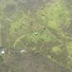
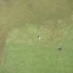
Large monolith aligned E-W dominating the col between Mill Loch and Calfsound. It is some 15ft 6in high, 5ft 6in wide at base, and 7ft wide across the N side at 5ft above ground. The thickness varies from 7.5in at base to 14in at middle of height. The top is deeply furrowed by weathering giving a distinctive profile. The stone stands on the S perimeter of a circular platform 10m diameter, 0.2m high, which is said to be a modern stack-footing. [R1],
Information from Orkney SMR (RGL) Sep 83.
Publication Account (1996)
Weathering has so furrowed this monolith as to give it a most formidably ancient appearance, enhancing its height (4.5m) and dominating position overlooking several chambered tombs and Calf Sound to the north (see Eday excursion) . Its careful location makes clear the intention of those who set it up that it should become a focal point in the is land landscape as viewed from the north and perhaps even from the sea, whence it has certainly taken on the status of a familiar landmark.
Information from ‘Exploring Scotland’s Heritage: Orkney’, (1996).
Field Visit (8 May 2013)
This standing stone is situated in a prominent location on the saddle between Mill Loch to the SSW and the Bay of Carrick to the NNE. Its broad faces are orientated in the same directions and it makes for a conspicuous landmark being roughly rectangular in outline and measuring 4.5m high, up to 2.13m broad and 0.55m thick. The surface of the stone is heavily weathered and thickly encrusted with lichen, but a small patch of graffiti is visible on its NNE face, while the deepest of the natural water-worn fissures eroded in the soft sandstone running from the summit to the stone’s base measures up to 0.25m deep. The ground at its foot has been scoured in a SSW to E arc and this has revealed two firmly set boulders serving as packing stones. A stack stand situated immediately to its NNE measures 5m in diameter over a platform of tightly fitting, grass-grown boulders 0.25m high. Rabbits have badly disturbed its perimeter on the NW to NE arc. It has a companion a few meters to the NE which overlies the SW arc of a neighbouring enclosure (HY53NE 10).
Visited by RCAHMS (ATW) 8 May 2013.

