
Following the launch of trove.scot in February 2025 we are now planning the retiral of some of our webservices. Canmore will be switched off on 24th June 2025. Information about the closure can be found on the HES website: Retiral of HES web services | Historic Environment Scotland
Corrydown


Cottage (19th Century), Garden (Period Unassigned)
Site Name Corrydown
Classification Cottage (19th Century), Garden (Period Unassigned)
Canmore ID 311909
Site Number NJ43SW 20
NGR NJ 4409 3313
Datum OSGB36 - NGR
Permalink http://canmore.org.uk/site/311909


![Watching brief, Site 2 including [012], Clashindarroch Windfarm, Aberdeenshire](http://i.rcahms.gov.uk/canmore/l/DP00321368.jpg)
![Watching brief, Site 2 including [012], Clashindarroch Windfarm, Aberdeenshire](http://i.rcahms.gov.uk/canmore/l/DP00321367.jpg)


![Watching brief, Site 2 including [012], Clashindarroch Windfarm, Aberdeenshire](http://i.rcahms.gov.uk/canmore/s/DP00321368.jpg)
![Watching brief, Site 2 including [012], Clashindarroch Windfarm, Aberdeenshire](http://i.rcahms.gov.uk/canmore/s/DP00321367.jpg)
- Council Aberdeenshire
- Parish Fyvie
- Former Region Grampian
- Former District Banff And Buchan
- Former County Aberdeenshire
Field Visit (2010)
NJ 4409 3313 A 19th-century stone cottage and garden recorded in 2010 appears to be all that remain of a much larger farm complex depicted on the 1st and 2nd Edition OS maps.
Archive: Aberdeenshire Council SMR and Forestry Commission, Aberdeenshire
Funder: Moray and Aberdeenshire Forestry Commission
Colin Shepherd
Watching Brief (11 January 2011 - 1 March 2014)
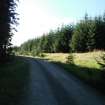
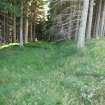
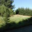
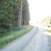
A watching brief took place during groundbreaking works for the construction of new access roads and turbine bases outside of previously forested areas. The exception to this was where a new access road
passed to the north-west of Site 2, a farmhouse and associated structures to the east of the Oxter Burn. No archaeological remains were recorded along the new access roads.
The Oxter Burn settlement was part of Corrydown Township and the OS Second Edition map of 1901 shows various farm buildings and other agricultural infrastructure including a pond and sluice ('Sl' on the map). The surviving elements of the site were surveyed by GPS and a route for the new road agreed. This aimed to avoid all parts of the site with the exception of a ditch leading east from the pond. Although the area had been badly affected by commercial forestry, the ditch (or possible mill lead) from the pond was located during the watching brief.
Information from Tamlin Barton, Georgia Marina Andreou Ptychion and Ian Suddaby (CFA Archaeology) March 2014
OASIS ID: cfaarcha1-168458
Watching Brief (July 2013 - January 2014)
Agreed mitigation measures were undertaken during the construction phase of Clashindarroch Windfarm to the south-west of Huntly, Aberdeenshire. these included the fencing-off of known sites, a watching brief during the construction of access roads outside of previously forested areas and a small excavation in advance of utility diversion works. No new sites were found during the watching brief but a ditch or possible mill-lead was recorded at corrydown (NJ43SW 20). An excavation took place at Queels (NJ44SE 24) in advance of utility service diversions and this recorded walls, surfaces and deposits associated with the farmstead, all of which appeared to date to the 19th century.
Funder: Vattenfall Wind Power Ltd.
CFA Archaeology Ltd
Information from Tamlin Barton, Georgia Marina Andreou Ptychion and Ian Suddaby (CFA Archaeology) March 2014
OASIS ID: cfaarcha1-168458

