
Plean


Pit(S) (Period Unknown), Rig And Furrow (Medieval) - (Post Medieval)
Site Name Plean
Classification Pit(S) (Period Unknown), Rig And Furrow (Medieval) - (Post Medieval)
Canmore ID 311443
Site Number NS88NE 158
NGR NS 85112 87367
NGR Description Centre
Datum OSGB36 - NGR
Permalink http://canmore.org.uk/site/311443


- Council Stirling
- Parish St Ninians
- Former Region Central
- Former District Stirling
- Former County Stirlingshire
NS88NE 158 8511 8735
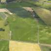
Rig and furrow and a scatter of pits of unknown origin have been recorded as cropmarks on oblique aerial photographs (RCAHMSAP 2010).
information from RCAHMS (DCC) 29 June 2011
Note (24 November 2022)
The location, classification and period of this site have been reviewed and changed from PIT(S) (PERIOD UNASSIGNED), RIG AND FURROW (MEDIEVAL) - (POST MEDIEVAL).

