
Bute, Couper Craig


Rock Shelter (Period Unknown)
Site Name Bute, Couper Craig
Classification Rock Shelter (Period Unknown)
Canmore ID 311027
Site Number NR97SE 98
NGR NR 9898 7233
Datum OSGB36 - NGR
Permalink http://canmore.org.uk/site/311027


- Council Argyll And Bute
- Parish North Bute
- Former Region Strathclyde
- Former District Argyll And Bute
- Former County Buteshire
Field Visit (15 October 2010)
NR97SE 98 9898 7233
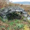
This rock shelter is situated in moorland at the NW tip of Bute, on a rocky WNW-facing slope set some 160m back from the present shoreline. It comprises a very large, roughly horizontal, slab resting on boulders on the E and W, the space beneath measuring 3.6m from N to S by 2.1m transversely and 1.1m in height. Tumble at the open N and S ends of the shelter may be the remains of walling. The location of the shelter was recorded by a hand-held GPS device (Garmin Legend with a 7m quoted accuracy).
Visited by RCAHMS (AGCH) 15 October 2010.

