
Strone Hill


Stone Circle (Neolithic) - (Bronze Age)
Site Name Strone Hill
Classification Stone Circle (Neolithic) - (Bronze Age)
Canmore ID 31009
Site Number NO25NE 32
NGR NO 2889 5676
Datum OSGB36 - NGR
Permalink http://canmore.org.uk/site/31009


- Council Angus
- Parish Lintrathen
- Former Region Tayside
- Former District Angus
- Former County Angus
NO25NE 32 NO 2889 5676.
Probable four-poster monument comprising one erect stone, (0.35m) though it is leaning and three fallen stones giving an original diameter of about 2.5m.
J R Sherriff and O Macknight 1985.
Measured Survey (1997)
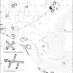
A detailed survey of Strone Hill, near Lintrathen in Angus, was undertaken at a scale of 1:1000 on behalf of Historic Scotland. The west end of Strone Hill covers an area of about 16.4ha (40.5 acres) and contains elements of a well-preserved prehistoric landscape, including up to three ring-cairns, a burial cairn, a possible four-poster, about 22 hut-circles (including some with double walls of Dalrulzion-type), a large number of small cairns, and linear fields defined by stony banks. Later remains include a farmstead with a kiln-barn, a number of other subrectangular buildings, huts, enclosures and rig. Two enigmatic stone-built features were surveyed at 1:100. One, known as 'The Abbot's Cross', is a cross of fairly regular plan measuring about 10m overall, whilst the other has five arms and measures up to 18m across. Both may relate to the boundaries of the lands held by Arbroath Abbey in the Middle Ages.
RCAHMS (DES 1997, 88)

