
Pricing Change
New pricing for orders of material from this site will come into place shortly. Charges for supply of digital images, digitisation on demand, prints and licensing will be altered.
Hallyards


Moated Site (Medieval), Rig And Furrow (Medieval) - (Post Medieval)
Site Name Hallyards
Classification Moated Site (Medieval), Rig And Furrow (Medieval) - (Post Medieval)
Canmore ID 30750
Site Number NO24NE 9
NGR NO 2790 4642
Datum OSGB36 - NGR
Permalink http://canmore.org.uk/site/30750


- Council Perth And Kinross
- Parish Alyth
- Former Region Tayside
- Former District Perth And Kinross
- Former County Perthshire
This site is listed in an Atlas of Scottish History (McNeill and MacQueen 1996) as a moated site.
Information from RCAHMS (DE) September 1997.
NO24NE 9 2790 4641.
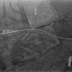
(NO 279 464) The name Hallyards (which occurs in 1478) almost certainly applies to the moated oblong shown on A.P. It measures 100 yds. by 80 yds. with a 20 yds. wide ditch and entrance in the E. Foundations containing lime, suggesting a medieval date, have been found within the moat. The Dundee water pipe runs through the centre.
J Meikle 1925
Field Visit (5 October 1970)
NO 2790 4641. On the low-lying arable land to the south of Hallyards farm are the much-reduced remains of a homestead moat consisting of a flat rectangular area enclosed by a broad shallow ditch c.20m in width and 0.7m in depth. The south side of the moat has been obliterated. No entrance can now be seen; the interior is featureless.
Surveyed at 1/2500
Visited by OS (WDJ) 5 October 1970
Aerial Photographic Transcription (27 January 1988 - 20 January 1994)
An aerial transcription was produced from oblique aerial photographs. Information from Historic Environment Scotland (BM) 31 March 2017.
Aerial Photographic Interpretation (22 December 1992)
This moated site is situated on a slight eminence in otherwise low-lying ground 600m NW of the River Isla, and, although it has been severely wasted by ploughing, its form and structure are clearly revealed by cropmarks on air photographs. Rectangular on plan, it measures at least 85m from NNE to SSW by 80m transversely within a ditch 8m broad; the course of what is probably a stone wall is indicated by a light-toned mark lying inside the line of the ditch on three sides. The teinds of Hallyards are on record in 1506, and in 1727 the house of Hallyards is described as protected from the floodwaters of the Isla 'by ditches encompassing it'.
Information from RCAHMS (JRS) 22 December 1992.
Dunkeld Rentale 1915.
Field Visit (1996 - 2003)
Russell Coleman managed an Historic Scotland funded project to record medieval moated sites in Scotland. Gazetteers were produced for each regional council area between 1996 and 2002 with an uncompleted overall review in 2002-03. The results of the first year of the project were published in Tayside and Fife Archaeological Journal, Volume 3 (1997).

